Toggle navigation
LMEC Home
Exhibitions
Georeferencing
Tools for Teachers
Collections
My Favorites
Sign Up / Log In
Search
Search the map portal
Map Collection
Map Collection
Map Sets
Search
Search
Search for
Search In
All Fields
Creator
Title
Subject
Place
Search All Digital Collections
Advanced Search
857 Results
My Search
Start Over
More Like
commonwealth:d7920269f
Remove constraint More Like: commonwealth:d7920269f
Filter your Search
Place
North and Central America
804
United States
644
New York
131
New England
130
Canada
86
New Jersey
79
North America
69
Massachusetts
49
more
Place
»
Topic
United States--History--Revolution, 1775-1783--Maps
330
New England--Maps
127
North America--Maps--Early works to 1800
59
Railroads--New England--Maps
50
United States--Maps--Early works to 1800
44
New Jersey--Maps
40
Canada--Maps--Early works to 1800
38
New York (State)--Maps
35
more
Topic
»
Date
Date range begin
–
Date range end
Current results range from
1623
to
2015
View distribution
Creator
Faden, William, 1749-1836
21
Robert Sayer and John Bennett (Firm)
19
Jefferys, Thomas, -1771
18
Clinton, Henry, Sir, 1738?-1795
17
Bellin, Jacques Nicolas, 1703-1772
16
Gibson, J. (John), active 1750-1792
14
Hills, John, active 1777-1819
14
Montrésor, John, 1736-1799
14
more
Creator
»
Format
Maps/Atlases
850
Manuscripts
9
Drawings/Illustrations
5
Paintings
3
Ephemera
1
Objects/Artifacts
1
Prints
1
Georeferenced
Yes
35
No
822
Collection
American Revolutionary War-Era Maps
673
MacLean Collection Map Library
379
William L. Clements Library Collection
310
Norman B. Leventhal Map & Education Center Collection
132
Boston and New England Maps
83
American Antiquarian Society Collection
19
David Judkins Weaver Papers
4
Sidney R. Knafel Map Collection at Phillips Academy
4
more
Collection
»
Available to use
No known restrictions
134
Creative Commons license
8
Search Constraints
Sort by relevance
relevance
title
date (asc)
date (desc)
Number of results to display per page
20 per page
10
per page
20
per page
50
per page
100
per page
View results as:
grid view
map view
Search Results
361.
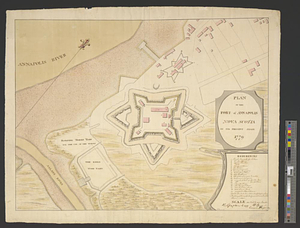
Plan of the fort of Annapolis Nova Scotia in its present state 1779
362.
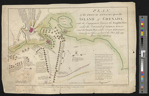
Plan of the French attacks upon the island of Grenada, with the engagement between the English fleet under the command of...
363.
Plan of the general attack on Fort Mifflin
364.
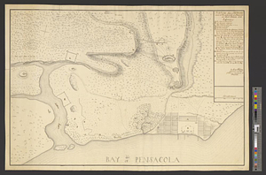
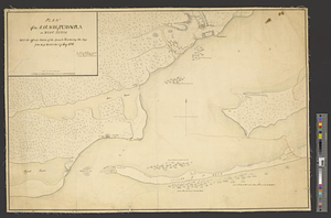
Plan of the harbour of Pensacola in West Florida with the different stations of the Spanish fleet during the siege from the 9...
365.
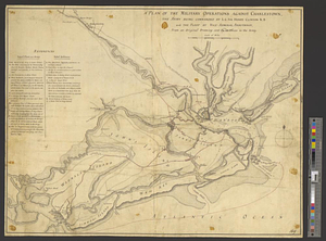
A plan of the military operations against Charlestown, the army being commanded by L.G. Sir Henry Clinton K.B. and the fleet by...
366.
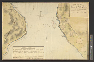
Plan of the narrows : shewing, the channel, shoal, depth of water, and the several battery's proposed on each side to prevent...
367.
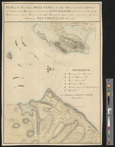
Plan of the narrows of Hell Gate, on the East River near which batteries of cannon, and morters, were erected on Long Island :...
368.
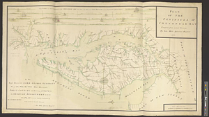
Plan of the peninsula of Chesopeak Bay : compiled from actual surveys
369.
Plan of the position of his majesty's troops at Rhode Island, after the defeat of the rebels the 29th of August 1778
370.
Plan of the post at Paulus's Hook, 24 July 1778
371.
Plan of the post of Portsmouth as it is occupied by his majesty's forces under the command of Major General Phillips, April...
372.
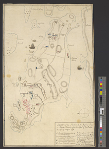
Plan of the scene of action at Charlestown in the province of South Carolina the 28th June 1776
373.
Plan of the seige [sic] of Charlestown in South Carolina
374.
Plan of the siege of Fort George and works adjacent at Pensacola in West Florida, 1781
375.
Plan of the town and environs of Newport, Rhode Island : exhibiting its defenses formed before the 8th of August 1778 when the...
376.
Plan of the town and environs of Newport, Rhode Island : exhibiting its defenses formed before the 8th of August 1778 when the...
377.
A plan of the town and harbour of Boston. : And the country adjacent with the road from Boston to Concord shewing the place of...
378.
A plan of the town and harbour of Boston and the country adjacent with the road from Boston to Concord shewing the place of the...
379.
Plan of the town and harbour of St. Augustin, in East Florida
380.
Plan of the town of Boston with the attack on Bunkers-Hill in the peninsula of Charlestown the 17th of June 1775
‹ Prev
Next ›
1
2
…
15
16
17
18
19
20
21
22
23
…
42
43
![Plan of the seige [sic] of Charlestown in South Carolina](https://bpldcassets.blob.core.windows.net/derivatives/metadata/commonwealth-oai:rb692949z/image_thumbnail_300.jpg)