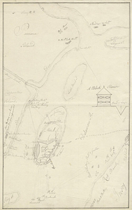
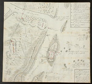
Plan of the general attack on Fort Mifflin
This map is also available in American Revolutionary Geographies Online (ARGO), a collections portal especially built for material relating to the American Revolutionary War Era. Visit ARGO to learn more about this item and explore the historical geography of North America in the late eighteenth century.
Item Information
- Title:
- Plan of the general attack on Fort Mifflin
- Creator:
- Fraser, Simon
- Date:
-
[1777?]
- Format:
-
Maps/Atlases
- Genre:
-
Manuscript maps
- Location:
- William L. Clements Library
- Collection (local):
-
William L. Clements Library Collection
- Subjects:
-
Fort Mifflin (Philadelphia, Pa.)--Maps
United States--History--Revolution, 1775-1783--Maps
- Places:
-
PennsylvaniaPhiladelphia (county)Philadelphia
Fort Mifflin
- Extent:
- 1 ms. map : col. ; 28.2 x 30.6 cm.
- Terms of Use:
-
The University of Michigan Library provides access to these materials for educational and research purposes. These materials may be under copyright. If you decide to use any of these materials, you are responsible for making your own legal assessment and securing any necessary permission. If you have questions about the collection, please contact the William L. Clements Library.
Contact host institution for more information.
- Scale:
-
Scale indeterminable.
- Language:
-
English
- Catalog Record:
-
Catalog record
- Notes:
-
Relief shown pictorially and by hachures.
Pen and ink and watercolor map showing Fort Mifflin on Mud Island during the 1777 attack by British land and naval forces.
Table of reference identifies gun positions and fort defenses.
- Identifier:
-
573
- Barcode:
-
B6194230