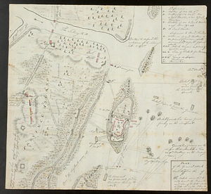
Plan of the British attack on Mud Island, Pennsylvania
This map is also available in American Revolutionary Geographies Online (ARGO), a collections portal especially built for material relating to the American Revolutionary War Era. Visit ARGO to learn more about this item and explore the historical geography of North America in the late eighteenth century.
Item Information
- Title:
- Plan of the British attack on Mud Island, Pennsylvania
- Title (alt.):
-
Block house
- Creator:
- André, John, 1751-1780
- Date:
-
[1777]
- Format:
-
Maps/Atlases
- Genre:
-
Manuscript maps
- Location:
- William L. Clements Library
- Collection (local):
-
William L. Clements Library Collection
- Subjects:
-
Philadelphia Campaign, 1777-1778--Maps
Fort Mifflin (Philadelphia, Pa.)--Maps
United States--History--Revolution, 1775-1783--Maps
- Places:
-
PennsylvaniaPhiladelphia (county)Philadelphia
Fort Mifflin
- Extent:
- 1 ms. map ; 37.5 x 24 cm
- Terms of Use:
-
The University of Michigan Library provides access to these materials for educational and research purposes. These materials may be under copyright. If you decide to use any of these materials, you are responsible for making your own legal assessment and securing any necessary permission. If you have questions about the collection, please contact the William L. Clements Library.
Contact host institution for more information.
- Scale:
-
Scale indeterminate.
- Language:
-
English
- Catalog Record:
-
Catalog record
- Notes:
-
Finished, pen and ink plan of attack on Fort Mifflin, showing naval vessels and batteries with their armament and lines of fire.
Notation in card catalog and Brun Addendum says that map was drawn November 15, 1777.
Inset shows elevation of one of the blockhouses or redoubts that formed part of the Fort Mifflin defenses.
- Notes (date):
-
This date is inferred.
- Identifier:
-
534
- Barcode:
-
B1939117