Toggle navigation
LMEC Home
Exhibitions
Georeferencing
Tools for Teachers
Collections
My Favorites
Sign Up / Log In
Search
Search the map portal
Map Collection
Map Collection
Map Sets
Search
Search
Search for
Search In
All Fields
Creator
Title
Subject
Place
Search All Digital Collections
Advanced Search
8757 Results
My Search
Start Over
More Like
commonwealth:cj82m377x
Remove constraint More Like: commonwealth:cj82m377x
Filter your Search
Place
North and Central America
5,988
United States
4,883
Massachusetts
2,079
Europe
1,396
Suffolk (county)
1,046
Boston
1,019
Canada
452
Asia
438
more
Place
»
Topic
Boston (Mass.)--Maps
586
United States--Maps
282
Real property--Massachusetts--Boston--Maps
175
Massachusetts--Maps
162
Landowners--Massachusetts--Boston--Maps
133
North America--Maps--Early works to 1800
106
New England--Maps
102
Europe--Maps
79
more
Topic
»
Date
Date range begin
–
Date range end
Current results range from
1482
to
2023
View distribution
Creator
United States. Hydrographic Office
595
O.H. Bailey & Co
148
Des Barres, Joseph F. W. (Joseph Frederick Wallet), 1722-1824
124
United States. Post Office Dept
120
Ptolemy, 2nd cent
100
Walling, Henry Francis, 1825-1888
94
Jefferys, Thomas, -1771
90
Geological Survey (U.S.)
86
more
Creator
»
Format
Maps/Atlases
8,697
Manuscripts
226
Prints
56
Books
36
Objects/Artifacts
10
Drawings/Illustrations
8
Posters
5
Georeferenced
Yes
871
No
7,886
Collection
Norman B. Leventhal Map & Education Center Collection
8,705
Boston and New England Maps
2,234
Urban Maps
2,023
Maritime Charts and Atlases
1,089
American Revolutionary War-Era Maps
665
Boston Redevelopment Authority Collection
87
Mapping Boston Collection
11
Richard H. Brown Revolutionary War Map Collection at Mount Vernon
10
more
Collection
»
Available to use
No known restrictions
8,554
Creative Commons license
91
Search Constraints
Sort by relevance
relevance
title
date (asc)
date (desc)
Number of results to display per page
20 per page
10
per page
20
per page
50
per page
100
per page
View results as:
grid view
map view
Search Results
41.
A map exhibiting a general view of the roads and inland navigation of Pennsylvania, and part of the adjacent states :...
42.
Map no. I
43.
A map of the middle British colonies in North America : first published by Mr. Lewis Evans, of Philadelphia, in 1755; and since...
44.
Map of the middle states of America : comprehends New-York, New-Jersey, Pennsylvania, Delaware, and the territory N.W. of Ohio
45.
Noui Belgii Nouaeque Angliae nec non partis Virginiae tabula
46.
Nova Anglia Novum Belgium et Virginia
47.
Nova Anglia, Novum Belgium et Virginia
48.
Nova Belgica et Anglia Nova
49.
Novi Belgii Novaeqve Angliae nec non partis Virginiae Tabula
50.
Pas caerte van Nieu Nederlandt en de Engelsche Virginies van Cabo Cod tot Cabo Canrick
51.
Pensylvania Nova Jersey et Nova York cum Regionibus ad Fluvium Delaware in America sitis
52.
The coast of a part of New England, New York, New Jersey, Pensilvania, Maryland, Virginia, and part of North Carolina &c. with...
53.
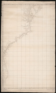
Map of coast from southern Florida to central New Jersey
54.
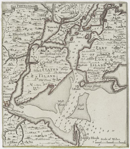
New York and Perthamboy Harbours
55.
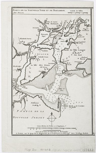
Ports de la Nouvelle York et Pertamboy : aux anglois
56.
Descripcion de la costa de Tierra Firme desde el Rio de la Empalizada hasta Cavo de Clara : Por las latitudes y longitudes de...
57.
Partie septentrionale des possessions Angloise en Amerique : pour servire d'intelligence à la guerre présente entre les...
58.
Pas-kaart vande zee kusten inde boght van Niew Engeland : tusschen de staaten Hoek en C. de Sable
59.
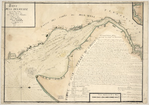
Baye de la Delaware avec les ports, sondes, dangers, bancs, &c. depuis les caps jusqu'a Philadelphie : d'après la carte de...
60.
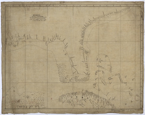
A draught of Delaware Bay
‹ Prev
Next ›
1
2
3
4
5
6
7
…
437
438