Map no. I
Item Information
- Title:
- Map no. I
- Title (alt.):
-
Map no. 1
Map number one
- Description:
-
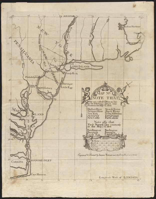
The Bill in the Chancery of New Jersey was filed by the Proprietors of East New Jersey to defend their position in a land dispute with settlers around Elizabeth. This is the first of the volume's three maps, which provides geographical context for the early grants and charters relevant to the dispute. The involvement of Boston engraver James Turner is evidence of the town's pre-eminence in the mid-18th century: when the Bill's author James Alexander needed the maps engraved, Benjamin Franklin advised him that Philadelphia?s craftsmen were not up to the job and recommended Turner instead.
- Engraver:
- Turner, James, -1759
- Printer:
- Parker, James, 1714-1770
- Date:
-
1747
- Format:
-
Maps/Atlases
- Location:
-
Boston Public Library
Norman B. Leventhal Map & Education Center - Collection (local):
-
Norman B. Leventhal Map & Education Center Collection
- Subjects:
-
New Jersey--Maps--Early works to 1800
New Jersey--Boundaries--Maps--Early works to 1800
Middle Atlantic States--Maps--Early works to 1800
Stair, John Dalrymple, Earl of, 1673-1747
Bond, Benjamin
- Places:
-
New Jersey
- Extent:
- 1 map ; 39 x 32 cm, folded to 19 x 12 cm
- Terms of Use:
-
No known copyright restrictions.
No known restrictions on use.
- Scale:
-
Scale approximately 1:2,400,000
- Language:
-
English
- Notes:
-
Covers area from Boston to Cape Hatteras with New Jersey partition and northern boundary lines.
Prime meridian: London.
"Engraved & printed by James Turner near the Town House Boston."
Includes names of the places in English and their Dutch equivalents.
Includes decorative cartouche.
- Identifier:
-
06_01_016155
- Call #:
-
G3810 1747 .M37
- Barcode:
-
39999085943908

![An exact map of New Jersey, Pensylvania [sic], New York, Maryland & Virginia, from the latest surveys](https://bpldcassets.blob.core.windows.net/derivatives/images/commonwealth:z603vp67m/image_thumbnail_300.jpg)
![La Pensilvania, la Nuova York, il Jersey Settentrio[na]le](https://bpldcassets.blob.core.windows.net/derivatives/images/commonwealth:z603vq53g/image_thumbnail_300.jpg)

