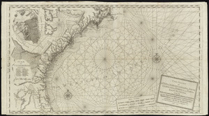
Map of coast from southern Florida to central New Jersey
This map is also available in American Revolutionary Geographies Online (ARGO), a collections portal especially built for material relating to the American Revolutionary War Era. Visit ARGO to learn more about this item and explore the historical geography of North America in the late eighteenth century.
Item Information
- Title:
- Map of coast from southern Florida to central New Jersey
- Date:
-
[1780?]
- Format:
-
Maps/Atlases
Manuscripts
- Location:
- Library of Congress Geography and Map Division
- Collection (local):
-
Library of Congress Collection
- Subjects:
-
Coasts--South Atlantic States--Maps--Early works to 1800
Coasts--Middle Atlantic States--Maps--Early works to 1800
Nautical charts--South Atlantic States--Early works to 1800
Nautical charts--Middle Atlantic States--Early works to 1800
South Atlantic States--Maps, Manuscript--Early works to 1800
Middle Atlantic States--Maps, Manuscript--Early works to 1800
- Places:
-
Florida
Georgia
North Carolina
South Carolina
Middle Atlantic (area)
- Extent:
- 1 map : ms. ; on sheet 103 x 61 cm.
- Terms of Use:
-
No known copyright restrictions.
This work is licensed for use under a Creative Commons Attribution Non-Commercial Share Alike License (CC BY-NC-SA).

- Scale:
-
Scale [ca. 1:2,050,000]
- Language:
-
Spanish
- Catalog Record:
-
https://lccn.loc.gov/99462707
- Notes:
-
Depths shown by soundings.
Prime meridian: Tenerife [?].
Pen-and-ink.
Watermarks: J. Honig & Zoonen; and, beehive.
Copy imperfect: Soiled, with part of right side of map missing, and with small tears along edges.
Place names in Spanish.
- Identifier:
-
ct006321

![Chart of the coast of America from St. Hellens Sound [to] St. Johns River](https://bpldcassets.blob.core.windows.net/derivatives/images/commonwealth:cj82m727j/image_thumbnail_300.jpg)