Toggle navigation
LMEC Home
Exhibitions
Georeferencing
Tools for Teachers
Collections
My Favorites
Sign Up / Log In
Search
Search the map portal
Map Collection
Map Collection
Map Sets
Search
Search
Search for
Search In
All Fields
Creator
Title
Subject
Place
Search All Digital Collections
Advanced Search
8682 Results
My Search
Start Over
More Like
commonwealth:cj82m119m
Remove constraint More Like: commonwealth:cj82m119m
Filter your Search
Place
North and Central America
5,921
United States
4,840
Massachusetts
2,088
Europe
1,392
Suffolk (county)
1,063
Boston
1,036
Canada
449
Asia
437
more
Place
»
Topic
Boston (Mass.)--Maps
582
United States--Maps
279
Real property--Massachusetts--Boston--Maps
175
Massachusetts--Maps
161
Landowners--Massachusetts--Boston--Maps
133
North America--Maps--Early works to 1800
103
New England--Maps
101
Europe--Maps
79
more
Topic
»
Date
Date range begin
–
Date range end
Current results range from
1482
to
2023
View distribution
Creator
United States. Hydrographic Office
595
O.H. Bailey & Co
148
Des Barres, Joseph F. W. (Joseph Frederick Wallet), 1722-1824
126
United States. Post Office Dept
120
Ptolemy, 2nd cent
100
Walling, Henry Francis, 1825-1888
94
Geological Survey (U.S.)
86
Jefferys, Thomas, -1771
85
more
Creator
»
Format
Maps/Atlases
8,622
Manuscripts
216
Prints
56
Books
36
Objects/Artifacts
10
Drawings/Illustrations
8
Posters
5
Georeferenced
Yes
873
No
7,809
Collection
Norman B. Leventhal Map & Education Center Collection
8,665
Boston and New England Maps
2,238
Urban Maps
1,997
Maritime Charts and Atlases
1,091
American Revolutionary War-Era Maps
643
Boston Redevelopment Authority Collection
87
Mapping Boston Collection
19
Richard H. Brown Revolutionary War Map Collection at Mount Vernon
6
more
Collection
»
Available to use
No known restrictions
8,506
Creative Commons license
79
Search Constraints
Sort by relevance
relevance
title
date (asc)
date (desc)
Number of results to display per page
20 per page
10
per page
20
per page
50
per page
100
per page
View results as:
grid view
map view
Search Results
41.
Particular draughts and plans of some of the principal towns and harbours belonging to the English, French, and Spaniards, in...
42.
Plan de Boston
43.
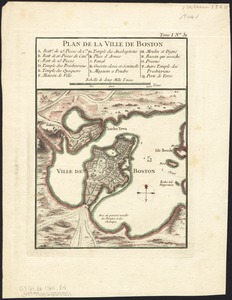
Plan de la ville de Boston
44.
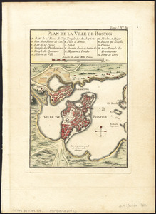
Plan de la ville de Boston
45.
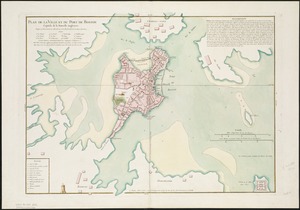
Plan de la ville et du port de Boston : capitale de la Nouvelle Angleterre
46.
A plan of Boston, from actual survey
47.
Thirty-miles round Boston
48.
The town of Boston in New England
49.
The town of Boston in New England
50.
The town of Boston in New England
51.
A chart of Boston Bay and vicinity
52.
Boston et ses environs
53.
Boston Harbour in New England
54.
Boston, with its environs
55.
Carte du port et havre de Boston avec les côtes adjacentes, dans laquel on a tracée les camps et les retranchemens occupé,...
56.
Carte du port et havre de Boston avec les côtes adjacentes, dans laquel on a tracée les camps et les retranchemens occupé,...
57.
A chart of the Harbour of Boston, with the soundings, sailing-marks, and other directions
58.
A large draught of New England, New York and Long Island
59.
A new and accurate chart of the harbour of Boston in New England in North America
60.
A new suruey of the harbour of Boston in New England
‹ Prev
Next ›
1
2
3
4
5
6
7
…
434
435