Toggle navigation
LMEC Home
Exhibitions
Georeferencing
Tools for Teachers
Collections
My Favorites
Sign Up / Log In
Search
Search the map portal
Map Collection
Map Collection
Map Sets
Search
Search
Search for
Search In
All Fields
Creator
Title
Subject
Place
Search All Digital Collections
Advanced Search
8743 Results
My Search
Start Over
More Like
commonwealth:cj82kk087
Remove constraint More Like: commonwealth:cj82kk087
Filter your Search
Place
North and Central America
5,974
United States
4,884
Massachusetts
2,079
Europe
1,396
Suffolk (county)
1,046
Boston
1,019
Canada
450
Asia
438
more
Place
»
Topic
Boston (Mass.)--Maps
586
United States--Maps
282
Real property--Massachusetts--Boston--Maps
175
Massachusetts--Maps
162
Landowners--Massachusetts--Boston--Maps
133
New England--Maps
106
North America--Maps--Early works to 1800
103
Europe--Maps
79
more
Topic
»
Date
Date range begin
–
Date range end
Current results range from
1482
to
2023
View distribution
Creator
United States. Hydrographic Office
595
O.H. Bailey & Co
148
Des Barres, Joseph F. W. (Joseph Frederick Wallet), 1722-1824
123
United States. Post Office Dept
119
Ptolemy, 2nd cent
100
Walling, Henry Francis, 1825-1888
94
Geological Survey (U.S.)
86
Jefferys, Thomas, -1771
86
more
Creator
»
Format
Maps/Atlases
8,683
Manuscripts
218
Prints
56
Books
36
Objects/Artifacts
10
Drawings/Illustrations
8
Posters
5
Georeferenced
Yes
869
No
7,874
Collection
Norman B. Leventhal Map & Education Center Collection
8,695
Boston and New England Maps
2,233
Urban Maps
2,023
Maritime Charts and Atlases
1,084
American Revolutionary War-Era Maps
664
Boston Redevelopment Authority Collection
87
William L. Clements Library Collection
30
American Antiquarian Society Collection
9
more
Collection
»
Available to use
No known restrictions
8,553
Creative Commons license
50
Search Constraints
Sort by relevance
relevance
title
date (asc)
date (desc)
Number of results to display per page
20 per page
10
per page
20
per page
50
per page
100
per page
View results as:
grid view
map view
Search Results
61.
Topographical map of the District of Columbia and a portion of Virginia
62.
The tourist's pocket map of the state of Virginia : exhibiting its internal improvements, roads, distances &c
63.
Washington and vicinity
64.
An historical and literary map of the Old Line State of Maryland : showing forth divers curious and notable facts relating to...
65.
Index chart of natural oyster bars, crab bottoms, clam bars and triangulation stations of Maryland surveyed by Maryland Shell...
66.
Map of eastern Virginia
67.
Map of eastern Virginia
68.
Map of the rail roads of New Jersey 1887
69.
Maryland
70.
New Jersey
71.
New Jersey showing forest area and its relation to the principal watersheds
72.
Northern New Jersey, showing the iron-ore & limestone districts
73.
Official map of the state of Virginia : from actual surveys by order of the executive, 1828 & 1859
74.
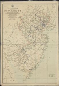
Post route map of the State of New Jersey showing post offices with the intermediate distances on mail routes in operation on...
75.
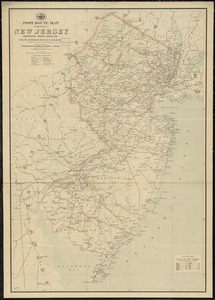
Post route map of the state of New Jersey showing post offices with the intermediate distances on mail routes in operation on...
76.
Rand, McNally & Co.'s New Jersey
77.
Relief map of New Jersey
78.
Seat of war in Virginia and Maryland
79.
Smith's topographical map of Virginia and Maryland
80.
The state of Maryland, from the best authorities
‹ Prev
Next ›
1
2
3
4
5
6
7
8
…
437
438