Toggle navigation
LMEC Home
Exhibitions
Georeferencing
Tools for Teachers
Collections
My Favorites
Sign Up / Log In
Search
Search the map portal
Map Collection
Map Collection
Map Sets
Search
Search
Search for
Search In
All Fields
Creator
Title
Subject
Place
Search All Digital Collections
Advanced Search
106 Results
My Search
Start Over
More Like
commonwealth:c534m2488
Remove constraint More Like: commonwealth:c534m2488
Filter your Search
Place
North and Central America
91
United States
90
Massachusetts
56
Virginia
13
Berkshire (county)
9
Boston
8
Suffolk (county)
8
Connecticut
5
more
Place
»
Topic
Massachusetts--Maps
20
United States--History--Civil War, 1861-1865--Maps
10
Berkshire County (Mass.)--Maps
8
Land use--Massachusetts--Maps
7
Virginia--History--Civil War, 1861-1865--Maps
7
Connecticut--Maps
6
Watersheds--Massachusetts--Maps
5
Boston Metropolitan Area (Mass.)--Maps
4
more
Topic
»
Date
Date range begin
–
Date range end
Current results range from
1762
to
2015
View distribution
Creator
MassGIS (Office : Mass.)
20
Massachusetts. Executive Office of Environmental Affairs
16
Michler, N. (Nathaniel), 1827-1881
15
New York Lithographing, Engraving and Printing Co.
12
Strasser, J.
12
Theilkuhl, F.
12
Weyss, J. E.
12
Geological Survey (U.S.)
10
more
Creator
»
Format
Maps/Atlases
103
Ephemera
2
Manuscripts
2
Books
1
Documents
1
Posters
1
Georeferenced
No
106
Collection
Norman B. Leventhal Map & Education Center Collection
103
David Judkins Weaver Papers
98
Boston and New England Maps
68
Urban Maps
9
American Antiquarian Society Collection
2
American Revolutionary War-Era Maps
2
Applied Geographics, Inc. Records
1
Massachusetts Real Estate Atlases
1
Available to use
No known restrictions
103
Search Constraints
Sort by relevance
relevance
title
date (asc)
date (desc)
Number of results to display per page
20 per page
10
per page
20
per page
50
per page
100
per page
View results as:
grid view
map view
Search Results
1.
Atlas of Berkshire County, Massachusetts
2.
Atlas of Berkshire County, Massachusetts
3.
County atlas of Berkshire Massachusetts
4.
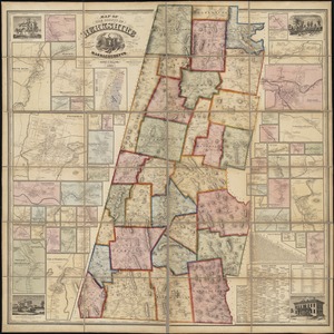
[Map of Berkshire County]
5.
A map of Berkshire County Mass
6.
Map of the county of Berkshire, Massachusetts : based upon the trigonometrical survey of the state
7.
[Map of the towns of Western Massachusetts]
8.
Province of the Massachusetts Bay & pursuant to an order made by the great & Genl. Court of the province June 11th 1762 : to me...
9.
The 1976 proposed regional open space plan
10.
Airbrush base for the Pelorus Linea region of Europa
11.
Aitoff's equal area projection of the sphere
12.
Antietam
13.
Appomattox Court House
14.
Azimuthal map projections
15.
Bermuda Hundred
16.
Black in New England 1840
17.
Boston bikemap : toward intelligent commuting
18.
Boston's bikemap : Arlington, Belmont, Brookline, Cambridge, Chelsea, Everett, Lexington, Malden, Medford, Needham, Newton,...
19.
Buffers around tributaries to the Wachusett Reservoir compared to 1985 urban landuse and currently protected open space in...
20.
Cape Cod
‹ Prev
Next ›
1
2
3
4
5
6


![[Map of Berkshire County]](https://bpldcassets.blob.core.windows.net/derivatives/images/commonwealth:wd376641h/image_thumbnail_300.jpg)

![[Map of the towns of Western Massachusetts]](https://bpldcassets.blob.core.windows.net/derivatives/images/commonwealth:6108vv02d/image_thumbnail_300.jpg)