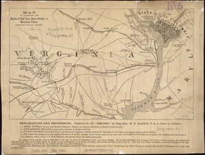
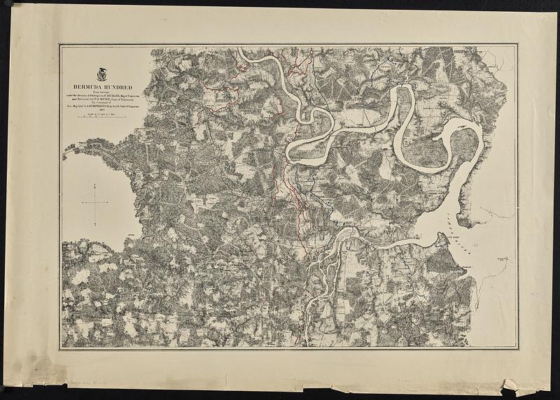
Bermuda Hundred
Item Information
- Title:
- Bermuda Hundred
- Contributor:
- Michler, N. (Nathaniel), 1827-1881
- Contributor:
- Michie, Peter Smith, 1839-1901
- Printer:
- New York Lithographing, Engraving and Printing Co.
- Name on Item:
-
from surveys under the direction of Bvt. Brig. Gen. N. Michler, Maj. of Engineers and Bvt. Lieut. Col. P.S. Michie, Capt. of Engineers, by command of Bvt. Maj. Genl. A.A. Humphreys, Brig. Genl. & Chief of Engineers. 1867
- Date:
-
[1867]
- Format:
-
Maps/Atlases
- Location:
-
Boston Public Library
Norman B. Leventhal Map & Education Center - Collection (local):
-
David Judkins Weaver Papers
- Subjects:
-
Bermuda Hundred Region (Va.)--History--Civil War, 1861-1865--Maps
United States--History--Civil War, 1861-1865--Campaigns--Maps
Virginia--History--Civil War, 1861-1865--Maps
- Places:
-
VirginiaChesterfield (county)Bermuda Hundred (transport point)
- Extent:
- 1 map : hand color ; 48 x 73 cm
- Terms of Use:
-
No known copyright restrictions.
No known restrictions on use.
- Publisher:
-
[Washington, D.C.] ; [New York] :
[Corps of Engineers?] ; N.Y. Lithographing, Engraving & Printing Co.
- Scale:
-
Scale 1:42,240. 1 1/2 inch to 1 mile
- Language:
-
English
- Notes:
-
Relief shown by hachures.
Map indicates roads, railroads, towns, drainage, vegetation, houses, and names of residents. Union and Confederate entrenchments are colored blue and red respectively.
- Notes (date):
-
This date is inferred.
- Notes (citation):
-
LC Civil War Maps (2nd ed.), 525b.4
- Identifier:
-
06_01_018871
- Call #:
-
Weaver folder 35 no.9