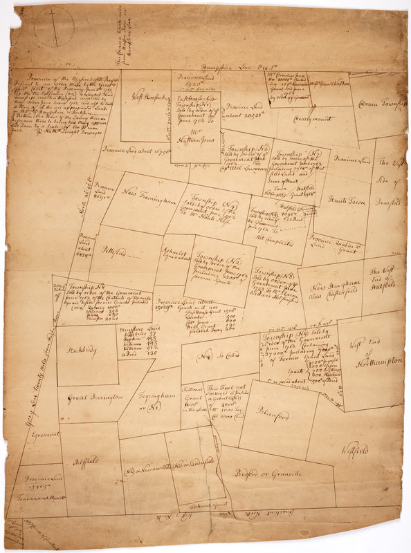
Province of the Massachusetts Bay & pursuant to an order made by the great & Genl. Court of the province June 11th 1762 : to me the subscriber (viz) to layout nine townships and ten thousand acres and sold by their order June second 1762 and also to take a plan of all the unappropriated land in the counties of Hampshire & Berkshire
This map is also available in American Revolutionary Geographies Online (ARGO), a collections portal especially built for material relating to the American Revolutionary War Era. Visit ARGO to learn more about this item and explore the historical geography of North America in the late eighteenth century.
Item Information
- Title:
- Province of the Massachusetts Bay & pursuant to an order made by the great & Genl. Court of the province June 11th 1762 : to me the subscriber (viz) to layout nine townships and ten thousand acres and sold by their order June second 1762 and also to take a plan of all the unappropriated land in the counties of Hampshire & Berkshire
- Description:
-
Subject: Map of Western Massachusetts divided into numbered plots and named towns. Some towns show how many acres were sold and to whom.
- Creator:
- Dwight, Nathaniel, 1712-1784
- Name on Item:
-
Nathl. Dwight surveyor.
- Date:
-
[1762]
- Format:
-
Maps/Atlases
Manuscripts
- Location:
- American Antiquarian Society
- Collection (local):
-
American Antiquarian Society Collection
- Subjects:
-
Massachusetts--Maps
Berkshire County (Mass.)--Maps
Hampden County (Mass.)--Maps
Hampshire County (Mass.)--Maps
Franklin County (Mass.)--Maps
- Places:
-
MassachusettsFranklin (county)
MassachusettsHampshire (county)
MassachusettsHampden (county)
MassachusettsBerkshire (county)
- Extent:
- 1 ms. map : ink ; 73 x 55 cm.
- Terms of Use:
-
Public Domain/No known restrictions on use. Contact host institution to download image.
Contact host institution for more information.
- Scale:
-
Scale not given
- Language:
-
English
- Catalog Record:
-
http://catalog.mwa.org/vwebv/holdingsInfo?bibId=490574
- Notes (date):
-
This date is inferred.
![[Map of the towns of Western Massachusetts]](https://bpldcassets.blob.core.windows.net/derivatives/images/commonwealth:6108vv02d/image_thumbnail_300.jpg)