Toggle navigation
LMEC Home
Exhibitions
Georeferencing
Tools for Teachers
Collections
My Favorites
Sign Up / Log In
Search
Search the map portal
Map Collection
Map Collection
Map Sets
Search
Search
Search for
Search In
All Fields
Creator
Title
Subject
Place
Search All Digital Collections
Advanced Search
8589 Results
My Search
Start Over
More Like
commonwealth:9s1618557
Remove constraint More Like: commonwealth:9s1618557
Filter your Search
Place
North and Central America
5,865
United States
4,793
Massachusetts
2,052
Europe
1,359
Suffolk (county)
1,034
Boston
1,007
Canada
459
Asia
422
more
Place
»
Topic
Boston (Mass.)--Maps
577
United States--Maps
273
Real property--Massachusetts--Boston--Maps
174
Massachusetts--Maps
160
Landowners--Massachusetts--Boston--Maps
132
North America--Maps--Early works to 1800
108
New England--Maps
99
Europe--Maps
78
more
Topic
»
Date
Date range begin
–
Date range end
Current results range from
1482
to
2023
View distribution
Creator
United States. Hydrographic Office
594
O.H. Bailey & Co
148
Des Barres, Joseph F. W. (Joseph Frederick Wallet), 1722-1824
123
United States. Post Office Dept
120
Ptolemy, 2nd cent
100
Walling, Henry Francis, 1825-1888
94
Jefferys, Thomas, -1771
87
Geological Survey (U.S.)
86
more
Creator
»
Format
Maps/Atlases
8,530
Manuscripts
217
Prints
56
Books
36
Objects/Artifacts
10
Drawings/Illustrations
8
Posters
4
Georeferenced
Yes
869
No
7,720
Collection
Norman B. Leventhal Map & Education Center Collection
8,549
Boston and New England Maps
2,204
Urban Maps
1,936
Maritime Charts and Atlases
1,081
American Revolutionary War-Era Maps
654
Boston Redevelopment Authority Collection
87
Richard H. Brown Revolutionary War Map Collection at Mount Vernon
12
Library and Archives Canada Collection
8
more
Collection
»
Available to use
No known restrictions
8,412
Creative Commons license
70
Search Constraints
Sort by relevance
relevance
title
date (asc)
date (desc)
Number of results to display per page
20 per page
10
per page
20
per page
50
per page
100
per page
View results as:
grid view
map view
Search Results
61.
A MAP of the BRITISH COLONIES in North America : WITH THE Roads, Distances, Limits, and Extent of the SETTLEMENTS, Humbly...
62.
A new and accurate map of the present seat of war in North America : from a late survey
63.
A new and correct map of North America : in which the places of the principal engagements during the present war are accurately...
64.
A new and correct map of North America : in which the places of the principal engagements during the present war are accurately...
65.
A plan of the attack made Nov.ber 27t. 1781 : by a detachment commanded by Brigadier-General Ross, from the Garrison of...
66.
A plan of the operations of the King's army under the command of General Sr. William Howe, K.B. in New York and east New...
67.
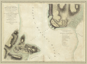
A plan of the surprise of Stoney Point, by a detachment of the American army commanded by Brigr. Genl. Wayne, on the 15th July...
68.
The seat of war, in New England, by an American volunteer : with the marches of the several corps sent by the colonies, towards...
69.
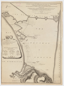
A sketch of Charleston Harbour : shewing the disposition of the British fleet under the command of Vice Adml. Mariot Arbuthnot...
70.
Suite du theatre de la guerre dans l'Amérique Septentrionale y compris le Golfe du Méxique
71.
An accurate map of Canada, with the adjacent countries : exhibiting the late seat of war between the English & French in those...
72.
Carte de la rivire du Cannada, la Terre Nevf, Cape Britton et la cotte de Lacadie
73.
Carte des découvertes qui ont été faites dans la partie occidentale du Canada sur les mémoires de Mr de la Varanderie [Vérendrye]
74.
Carte du Canada et des Etats-Unis de l'Amérique Septentrionale
75.
Carte d'une partie du Nord Amerique dans la quelle se trouvent les isles et les provinces suivantes : l'Isle de la Terre-Neuve...
76.
Carte generale du Canada ou Nouvelle France
77.
Cours du fleuve St. Laurent : deuxieme feuille : depuis Quebec jusqu'au havre des Papinachouas
78.
Cours du fleuve St. Laurent : premiere feuille : contenant depuis le Lac Ontario jusqu'a Quebec
79.
Cours du fleuve St. Laurent : troisieme feuille : depuis le mont Camille jusqu'a l'isle d'Anticosti
80.
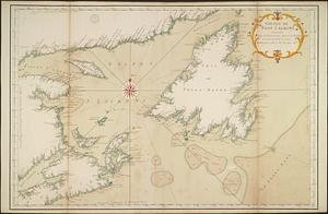
Golphe de Saint Laurent, contenant l'Isle de Terreneuve, Detroit de Belle-Isle, entrée du Fleuve St. Laurent, Isle Royale, et...
‹ Prev
Next ›
1
2
3
4
5
6
7
8
…
429
430


![Carte des découvertes qui ont été faites dans la partie occidentale du Canada sur les mémoires de Mr de la Varanderie [Vérendrye]](https://bpldcassets.blob.core.windows.net/derivatives/images/commonwealth:wp98ck41z/image_thumbnail_300.jpg)