Toggle navigation
LMEC Home
Exhibitions
Georeferencing
Tools for Teachers
Collections
My Favorites
Sign Up / Log In
Search
Search the map portal
Map Collection
Map Collection
Map Sets
Search
Search
Search for
Search In
All Fields
Creator
Title
Subject
Place
Search All Digital Collections
Advanced Search
8577 Results
My Search
Start Over
More Like
commonwealth:7h149z36n
Remove constraint More Like: commonwealth:7h149z36n
Filter your Search
Place
North and Central America
5,872
United States
4,789
Massachusetts
2,063
Europe
1,359
Suffolk (county)
1,036
Boston
1,009
Canada
449
Asia
422
more
Place
»
Topic
Boston (Mass.)--Maps
578
United States--Maps
273
Real property--Massachusetts--Boston--Maps
174
Massachusetts--Maps
160
Landowners--Massachusetts--Boston--Maps
132
North America--Maps--Early works to 1800
103
New England--Maps
99
Europe--Maps
78
more
Topic
»
Date
Date range begin
–
Date range end
Current results range from
1482
to
2023
View distribution
Creator
United States. Hydrographic Office
594
O.H. Bailey & Co
148
Des Barres, Joseph F. W. (Joseph Frederick Wallet), 1722-1824
123
United States. Post Office Dept
120
Ptolemy, 2nd cent
100
Walling, Henry Francis, 1825-1888
94
Geological Survey (U.S.)
86
Jefferys, Thomas, -1771
85
more
Creator
»
Format
Maps/Atlases
8,518
Manuscripts
219
Prints
56
Books
36
Objects/Artifacts
10
Drawings/Illustrations
8
Posters
4
Georeferenced
Yes
870
No
7,707
Collection
Norman B. Leventhal Map & Education Center Collection
8,558
Boston and New England Maps
2,215
Urban Maps
1,936
Maritime Charts and Atlases
1,086
American Revolutionary War-Era Maps
635
Boston Redevelopment Authority Collection
87
Mapping Boston Collection
8
Sidney R. Knafel Map Collection at Phillips Academy
7
more
Collection
»
Available to use
No known restrictions
8,409
Creative Commons license
64
Search Constraints
Sort by relevance
relevance
title
date (asc)
date (desc)
Number of results to display per page
20 per page
10
per page
20
per page
50
per page
100
per page
View results as:
grid view
map view
Search Results
7141.
Scotland with the principal roads from the best authorities
7142.
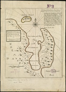
The Scots settlement in America called New Caledonia, A.D. 1699
7143.
A Scott-Map of Boston, Massachusetts
7144.
The Scrimshaw historical map of Cape Cod
7145.
S.e. coast of Nova Scotia : from the most recent British surveys
7146.
The s.e. coast of the United States and its relation to the British West India colonies
7147.
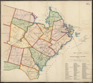
Sea coast of Rockingham County, N.H
7148.
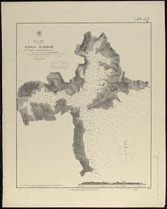
Sea of Japan, Oki Island, Saigo Harbor : from a Japanese government survey in 1879
7149.
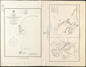
Sea of Japan, west coast of Yezo, dangers off the south point of Okosiri Island : from an examination by the officers of the...
7150.
Seagull Harbour, Gretton Bay, Wollaston Island, Tierra del Fuego
7151.
Seagull Harbour, Gretton Bay, Wollaston Island, Tierra del Fuego
7152.
Sears Park conceptual site plan with historic waterway
7153.
The seat of action, between the British and American forces : or an authentic plan of the western part of Long Island, with the...
7154.
Seat of the Russo-Turkish War
7155.
The seat of war
7156.
The seat of war : birds eye view of Virginia, Maryland, Delaware, and the District of Columbia
7157.
The seat of war in France, showing the scene of M'Mahon's defeat and capitulation, Paris and its environs, and its railroad...
7158.
The seat of war in New England, by an American volunteer : with the marches of the several corps sent by the Colonies towards...
7159.
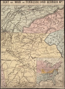
Seat of war in Tennesse and Georgia : 6D
7160.
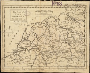
The seat of war in the circle of Westphalia
‹ Prev
Next ›
1
2
…
354
355
356
357
358
359
360
361
362
…
428
429