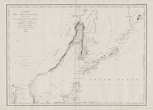
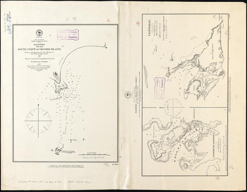
Sea of Japan, west coast of Yezo, dangers off the south point of Okosiri Island : from an examination by the officers of the French frigate Themis, 1880 ; Pacific Ocean, Japan Islands, harbors in the Meiaco-sima Group : from the Brit. Admty. chart no. 2105 with soundings by the imp. German Corvette Cyclop, Capt. Lieut. von Reiche comdg. 1876.
Item Information
- Title:
- Sea of Japan, west coast of Yezo, dangers off the south point of Okosiri Island : from an examination by the officers of the French frigate Themis, 1880 ; Pacific Ocean, Japan Islands, harbors in the Meiaco-sima Group : from the Brit. Admty. chart no. 2105 with soundings by the imp. German Corvette Cyclop, Capt. Lieut. von Reiche comdg. 1876.
- Issuing body:
- United States. Hydrographic Office
- Date:
-
1880
- Format:
-
Maps/Atlases
- Genre:
-
Nautical charts
- Location:
-
Boston Public Library
Norman B. Leventhal Map & Education Center - Collection (local):
-
Norman B. Leventhal Map & Education Center Collection
- Subjects:
-
Aonae Cape (Japan)--Maps
Funauki Bay (Japan)--Maps
Miyako Island (Japan)--Maps
Coasts--Japan--Maps
Harbors--Japan--Maps
Nautical charts--Japan--Funauki Bay
Nautical charts--Japan--Miyako Island
- Places:
-
JapanMiyako-jima (island)
Aonae Misaki
Funauki-wan
- Extent:
- 3 maps on 2 sheets : joined into 1 sheet ; 50 x 64 cm
- Terms of Use:
-
No known copyright restrictions.
No known restrictions on use.
- Publisher:
-
Washington, D.C. :
Hydrographic Office
- Scale:
-
Scale approximately 1:26,000
Scale approximately 1:39,600
Scale approximately 1:150,000
- Language:
-
English
- Table of Contents:
-
Dangers off the south point of Okosiri Island
Cockburn Harbor ; Taipinsan
- Notes:
-
Relief shown by hachures and spot heights. Depths shown by soundings.
Two separate maps joined into 1 sheet.
- Identifier:
-
06_01_017553
- Call #:
-
G9096.P5 svar .U55 nos. 806 & 880
- Barcode:
-
39999085959763