Toggle navigation
LMEC Home
Exhibitions
Georeferencing
Tools for Teachers
Collections
My Favorites
Sign Up / Log In
Search
Search the map portal
Map Collection
Map Collection
Map Sets
Search
Search
Search for
Search In
All Fields
Creator
Title
Subject
Place
Search All Digital Collections
Advanced Search
8942 Results
My Search
Start Over
More Like
commonwealth:7h149x05f
Remove constraint More Like: commonwealth:7h149x05f
Filter your Search
Place
North and Central America
6,170
United States
5,088
Massachusetts
2,134
Europe
1,396
Suffolk (county)
1,207
Boston
1,180
Canada
464
Asia
438
more
Place
»
Topic
Boston (Mass.)--Maps
752
United States--Maps
330
Real property--Massachusetts--Boston--Maps
195
Massachusetts--Maps
166
City planning--Massachusetts--Boston--Maps
157
Landowners--Massachusetts--Boston--Maps
142
New England--Maps
104
North America--Maps--Early works to 1800
103
more
Topic
»
Date
Date range begin
–
Date range end
Current results range from
1482
to
2023
View distribution
Creator
United States. Hydrographic Office
595
Boston Redevelopment Authority
162
O.H. Bailey & Co
148
Des Barres, Joseph F. W. (Joseph Frederick Wallet), 1722-1824
124
United States. Post Office Dept
120
Ptolemy, 2nd cent
100
Walling, Henry Francis, 1825-1888
94
Geological Survey (U.S.)
88
more
Creator
»
Format
Maps/Atlases
8,882
Manuscripts
218
Prints
56
Books
36
Objects/Artifacts
10
Drawings/Illustrations
8
Posters
5
Georeferenced
Yes
887
No
8,055
Collection
Norman B. Leventhal Map & Education Center Collection
8,729
Boston and New England Maps
2,358
Urban Maps
2,143
Maritime Charts and Atlases
1,084
American Revolutionary War-Era Maps
707
Boston Redevelopment Authority Collection
191
William L. Clements Library Collection
43
Maps from AAS
33
more
Collection
»
Available to use
No known restrictions
8,670
Creative Commons license
76
Search Constraints
Sort by relevance
relevance
title
date (asc)
date (desc)
Number of results to display per page
20 per page
10
per page
20
per page
50
per page
100
per page
View results as:
grid view
map view
Search Results
7721.
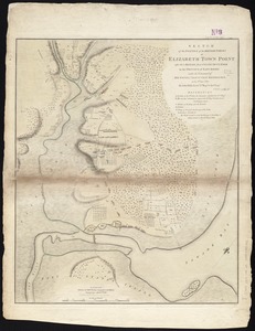
Sketch of the position of the British forces at Elizabeth Town Point after their return from Connecticut Farm, in the province...
7722.
[Sketch of the region of the island of Cape Breton, between the parallels of forty-five and forty-eight degrees of latitude]
7723.
Sketch of the states of Massachusetts, Connecticut, and Rhode Island, and parts of New Hampshire & New York exhibiting the...
7724.
Sketch of the states of Massachusetts, Connecticut, and Rhode Island, and parts of New Hampshire & New York exhibiting the...
7725.
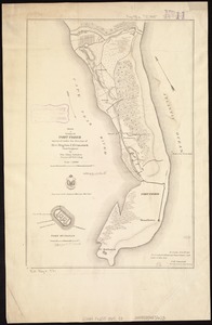
Sketch of vicinity of Fort Fisher
7726.
Sketch plan showing the existing and proposed public reservations upon the banks of the Charles between Waltham line and...
7727.
Sketch showing a feasible canal route, Allegheny River to Lake Erie.
7728.
Sketches of a building to be constructed in City Hall Plaza north of Boston City Hall
7729.
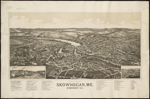
Skowhegan, Me : Somerset Co
7730.
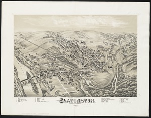
Slatington : Pennsylvania
7731.
A small map of the sea coast of New England together with the outlines of several of the provinces lying thereon, 1738
7732.
Smith's topographical map of Virginia and Maryland
7733.
Smyrna, Delaware : 1885
7734.
Society Islands, the n.w. coast of Tahiti from Papeete to Point Venus, embracing the harbors of Papeete, Tau-noa and Papawa and...
7735.
Soil reconnoissance, Montana 1925 : Chouteau County
7736.
Solar and lunar eclipse diagrams
7737.
Somerset Co., Penn'a
7738.
Sooke sheet, Vancouver Island, British Columbia
7739.
South Acton, Mass : 1886
7740.
South Africa
‹ Prev
Next ›
1
2
…
383
384
385
386
387
388
389
390
391
…
447
448
![[Sketch of the region of the island of Cape Breton, between the parallels of forty-five and forty-eight degrees of latitude]](https://bpldcassets.blob.core.windows.net/derivatives/images/commonwealth:4m90fh38k/image_thumbnail_300.jpg)