Toggle navigation
LMEC Home
Exhibitions
Georeferencing
Tools for Teachers
Collections
My Favorites
Sign Up / Log In
Search
Search the map portal
Map Collection
Map Collection
Map Sets
Search
Search
Search for
Search In
All Fields
Creator
Title
Subject
Place
Search All Digital Collections
Advanced Search
9052 Results
My Search
Start Over
More Like
commonwealth:7d27c9549
Remove constraint More Like: commonwealth:7d27c9549
Filter your Search
Place
North and Central America
6,283
United States
5,201
Massachusetts
2,155
Suffolk (county)
1,403
Europe
1,396
Boston
1,376
Canada
449
Asia
438
more
Place
»
Topic
Boston (Mass.)--Maps
677
City planning--Massachusetts--Boston--Maps
418
United States--Maps
282
Urban renewal--Massachusetts--Boston--Maps
252
Real property--Massachusetts--Boston--Maps
217
Massachusetts--Maps
162
Landowners--Massachusetts--Boston--Maps
136
North America--Maps--Early works to 1800
103
more
Topic
»
Date
Date range begin
–
Date range end
Current results range from
1482
to
2023
View distribution
Creator
United States. Hydrographic Office
595
Boston Redevelopment Authority
390
O.H. Bailey & Co
148
Des Barres, Joseph F. W. (Joseph Frederick Wallet), 1722-1824
123
United States. Post Office Dept
120
Ptolemy, 2nd cent
100
Walling, Henry Francis, 1825-1888
94
Geological Survey (U.S.)
86
more
Creator
»
Format
Maps/Atlases
8,991
Manuscripts
215
Prints
56
Books
36
Objects/Artifacts
10
Drawings/Illustrations
9
Posters
5
Georeferenced
Yes
870
No
8,182
Collection
Norman B. Leventhal Map & Education Center Collection
8,696
Boston and New England Maps
2,586
Urban Maps
2,373
Maritime Charts and Atlases
1,083
American Revolutionary War-Era Maps
620
Boston Redevelopment Authority Collection
438
William L. Clements Library Collection
3
Mapping Boston Collection
2
more
Collection
»
Available to use
No known restrictions
8,904
Creative Commons license
49
Search Constraints
Sort by relevance
relevance
title
date (asc)
date (desc)
Number of results to display per page
20 per page
10
per page
20
per page
50
per page
100
per page
View results as:
grid view
map view
Search Results
7001.
Plymouth, Grafton County, N.H : 1883
7002.
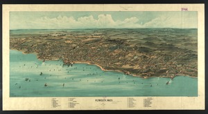
Plymouth, Mass : 1882
7003.
Plymouth, Mass
7004.
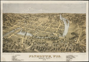
Plymouth, Wis : Sheboygan County, 1870
7005.
A pocket companion of Ireland : containing all the cities, market towns, boroughs, all ye great roads, and principal cross...
7006.
Pocket map of the city of Worcester, Mass : showing all streets, parks, distances, street car routes, location of public...
7007.
Pocket map showing the railroads, street railways, manufactories, deep water connections, blocks and subdivisions of the city...
7008.
Podrobnaia militernaia karta, po granits Rossii s Turtsieiu
7009.
The Point of Pines, Revere, Mass : on the Atlantic Ocean, eight miles north east of Boston : the most beautiful sea shore...
7010.
Poland
7011.
Poland
7012.
Poland & Lithuania
7013.
Poland, shewing the claims of Russia, Prussia & Austria, until the late depredations, the extent of which cannot as yet be...
7014.
Poli Arctici, et circumiacentium terrarum descriptio novissima
7015.
Political map of California. 1888
7016.
Political map of Connecticut 1888 ; Political map of New York 1888
7017.
Political map of Europe
7018.
Political map of Indiana. 1888
7019.
Political map of Michigan 1888
7020.
Political map of New Jersey 1888
‹ Prev
Next ›
1
2
…
347
348
349
350
351
352
353
354
355
…
452
453