Toggle navigation
LMEC Home
Exhibitions
Georeferencing
Tools for Teachers
Collections
My Favorites
Sign Up / Log In
Search
Search the map portal
Map Collection
Map Collection
Map Sets
Search
Search
Search for
Search In
All Fields
Creator
Title
Subject
Place
Search All Digital Collections
Advanced Search
8809 Results
My Search
Start Over
More Like
commonwealth:6t053p295
Remove constraint More Like: commonwealth:6t053p295
Filter your Search
Place
North and Central America
6,030
United States
4,955
Massachusetts
2,102
Europe
1,396
Suffolk (county)
1,068
Boston
1,041
Canada
459
Asia
438
more
Place
»
Topic
Boston (Mass.)--Maps
586
United States--Maps
282
Real property--Massachusetts--Boston--Maps
175
Massachusetts--Maps
162
Landowners--Massachusetts--Boston--Maps
133
North America--Maps--Early works to 1800
108
New England--Maps
102
New England--Maps--Early works to 1800
97
more
Topic
»
Date
Date range begin
–
Date range end
Current results range from
1482
to
2023
View distribution
Creator
United States. Hydrographic Office
595
O.H. Bailey & Co
148
Des Barres, Joseph F. W. (Joseph Frederick Wallet), 1722-1824
125
United States. Post Office Dept
120
Ptolemy, 2nd cent
100
Walling, Henry Francis, 1825-1888
94
Jefferys, Thomas, -1771
89
Geological Survey (U.S.)
86
more
Creator
»
Format
Maps/Atlases
8,749
Manuscripts
217
Prints
56
Books
36
Objects/Artifacts
10
Drawings/Illustrations
8
Posters
5
Georeferenced
Yes
877
No
7,932
Collection
Norman B. Leventhal Map & Education Center Collection
8,737
Boston and New England Maps
2,259
Urban Maps
2,029
Maritime Charts and Atlases
1,093
American Revolutionary War-Era Maps
693
Boston Redevelopment Authority Collection
87
Mapping Boston Collection
41
Richard H. Brown Revolutionary War Map Collection at Mount Vernon
19
more
Collection
»
Available to use
No known restrictions
8,558
Creative Commons license
128
Search Constraints
Sort by relevance
relevance
title
date (asc)
date (desc)
Number of results to display per page
20 per page
10
per page
20
per page
50
per page
100
per page
View results as:
grid view
map view
Search Results
101.
A new and correct map of North America : in which the places of the principal engagements during the present war are accurately...
102.
A new and correct map of North America : in which the places of the principal engagements during the present war are accurately...
103.
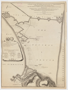
A plan of the attack made Nov.ber 27t. 1781 : by a detachment commanded by Brigadier-General Ross, from the Garrison of...
104.
A plan of the operations of the King's army under the command of General Sr. William Howe, K.B. in New York and east New...
105.
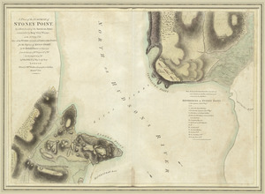
A plan of the surprise of Stoney Point, by a detachment of the American army commanded by Brigr. Genl. Wayne, on the 15th July...
106.
A sketch of Charleston Harbour : shewing the disposition of the British fleet under the command of Vice Adml. Mariot Arbuthnot...
107.
Suite du theatre de la guerre dans l'Amérique Septentrionale y compris le Golfe du Méxique
108.
Théatre de la guerre en Amerique, avec les Isles Antilles : projetté et assujettie aux observations
109.
Baye et port de Boston
110.
Baye et port de Boston
111.
Boston et ses environs
112.
Boston Harbour in New England
113.
Boston, with its environs
114.
Carte du port et havre de Boston avec les côtes adjacentes, dans laquel on a tracée les camps et les retranchemens occupé,...
115.
Carte du port et havre de Boston avec les côtes adjacentes, dans laquel on a tracée les camps et les retranchemens occupé,...
116.
Carte particuliere du havre de Boston : avec les sondes les bancs de Sable, les rochers les Amaies et les autres directions...
117.
Carte particuliere du havre de Boston : avec les sondes les bancs de Sable, les rochers les Amaies et les autres directions...
118.
A chart of the harbour of Boston
119.
A chart of the Harbour of Boston, with the soundings, sailing-marks, and other directions
120.
A large draught of New England, New York and Long Island
‹ Prev
Next ›
1
2
3
4
5
6
7
8
9
10
…
440
441