Toggle navigation
LMEC Home
Exhibitions
Georeferencing
Tools for Teachers
Collections
My Favorites
Sign Up / Log In
Search
Search the map portal
Map Collection
Map Collection
Map Sets
Search
Search
Search for
Search In
All Fields
Creator
Title
Subject
Place
Search All Digital Collections
Advanced Search
85 Results
My Search
Start Over
More Like
commonwealth:6395x851t
Remove constraint More Like: commonwealth:6395x851t
Filter your Search
Place
North and Central America
70
United States
68
New York
40
Europe
6
Erie (county)
5
Lower Bay
5
New Jersey
5
Upper Bay
5
more
Place
»
Topic
Coastlines
9
Navigation
8
Harbors
5
Aeronautics
3
Rivers
2
Streets
2
1706
1
Atlantic Coast (U.S.)
1
more
Topic
»
Date
Date range begin
–
Date range end
Current results range from
1540
to
2005
View distribution
Creator
Cram, George Franklin, 1841-1928
11
Rand McNally and Company
7
Bache, A. D. (Alexander Dallas), 1806-1867
6
Matthews-Northrup Company
5
Smith, Benjamin E. (Benjamin Eli), 1857-1913
5
Mitchell, S. Augustus (Samuel Augustus), 1792-1868
4
Faden, William, 1749-1836
3
Johnson, A. J. (Alvin Jewett), 1827-1884
3
more
Creator
»
Format
Maps/Atlases
83
Books
1
Prints
1
Georeferenced
No
85
Collection
Robert E. Diefenbach Map Collection at Phillips Academy
75
Ralph Finos Map Collection at Phillips Academy
8
American Revolutionary War-Era Maps
1
Norman B. Leventhal Map & Education Center Collection
1
Richard H. Brown Revolutionary War Map Collection at Mount Vernon
1
Available to use
No known restrictions
81
Creative Commons license
4
Search Constraints
Sort by relevance
relevance
title
date (asc)
date (desc)
Number of results to display per page
20 per page
10
per page
20
per page
50
per page
100
per page
View results as:
grid view
map view
Search Results
1.
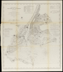
New York Bay and Harbor
2.
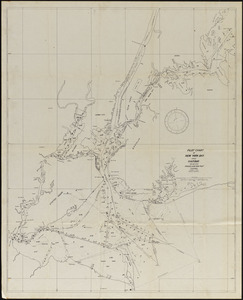
Pilot chart of New York Bay and Harbor for use with Krause's New York pilot courses
3.
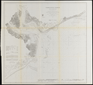
Charleston Harbor and its approaches
4.
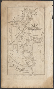
New York
5.
New York Harbor
6.
Portsmouth Harbor to Boston Harbor
7.
The Clermont on the Hudson River, 1810
8.
Charts of several harbours, and divers parts of the coast of North America, from New York south westwards to the Gulph of Mexico
9.
A new map of the world according to Wrights alias Mercators projection &c : drawn from the newest and the most exact...
10.
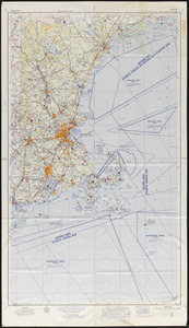
Boston sectional aeronautical chart
11.
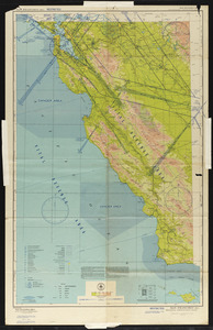
San Francisco (RS-1) sectional aeronautical chart
12.
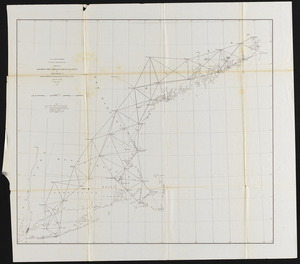
Sketch A, showing the primary triangulation in section I and the connection of the baselines in sections I and II
13.
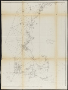
Sketch A showing the progress of the survey in Section No. 1 from 1844 to 1854
14.
Sketch showing the progress of the survey on the Atlantic, Gulf of Mexico, and Pacific coast of the United States
15.
Afrika
16.
Americae sive novi orbis, nova descriptio.
17.
Amherst map & guide
18.
Ancient Britain II
19.
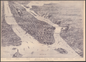
Bird's-eye view of New York City in 1897
20.
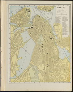
Boston
‹ Prev
Next ›
1
2
3
4
5