Toggle navigation
LMEC Home
Exhibitions
Georeferencing
Tools for Teachers
Collections
My Favorites
Sign Up / Log In
Search
Search the map portal
Map Collection
Map Collection
Map Sets
Search
Search
Search for
Search In
All Fields
Creator
Title
Subject
Place
Search All Digital Collections
Advanced Search
8695 Results
My Search
Start Over
More Like
commonwealth:4m90fp957
Remove constraint More Like: commonwealth:4m90fp957
Filter your Search
Place
North and Central America
5,926
United States
4,844
Massachusetts
2,079
Europe
1,396
Suffolk (county)
1,046
Boston
1,019
Canada
449
Asia
438
more
Place
»
Topic
Boston (Mass.)--Maps
586
United States--Maps
282
Real property--Massachusetts--Boston--Maps
175
Massachusetts--Maps
162
Landowners--Massachusetts--Boston--Maps
133
North America--Maps--Early works to 1800
103
New England--Maps
102
Europe--Maps
79
more
Topic
»
Date
Date range begin
–
Date range end
Current results range from
1482
to
2023
View distribution
Creator
United States. Hydrographic Office
595
O.H. Bailey & Co
148
Des Barres, Joseph F. W. (Joseph Frederick Wallet), 1722-1824
123
United States. Post Office Dept
120
Ptolemy, 2nd cent
100
Walling, Henry Francis, 1825-1888
94
Geological Survey (U.S.)
86
Jefferys, Thomas, -1771
85
more
Creator
»
Format
Maps/Atlases
8,634
Manuscripts
215
Prints
56
Books
37
Objects/Artifacts
10
Drawings/Illustrations
8
Posters
5
Georeferenced
Yes
869
No
7,826
Collection
Norman B. Leventhal Map & Education Center Collection
8,694
Boston and New England Maps
2,233
Urban Maps
2,023
Maritime Charts and Atlases
1,083
American Revolutionary War-Era Maps
616
Boston Redevelopment Authority Collection
87
U.S. Government Documents Maps Collection
1
Available to use
No known restrictions
8,553
Creative Commons license
47
Search Constraints
Sort by relevance
relevance
title
date (asc)
date (desc)
Number of results to display per page
20 per page
10
per page
20
per page
50
per page
100
per page
View results as:
grid view
map view
Search Results
21.
Collins' map of the seat of war
22.
Cruchley's map of Central Europe, shewing the new political divisions : also all the railways, &c.
23.
The eclipse map of the seat of war, between France and Prussia, 1870
24.
Harper's war map of France
25.
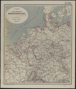
Karte des deutsch-französischen kriegsschauplatzes
26.
Letts's war map of Central Europe
27.
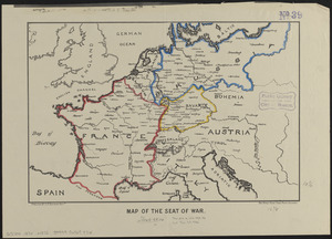
Map of the seat of war
28.
Philips' map of the seat of war shewing the country from Paris to Berlin, with the Rhine Provinces on a large scale
29.
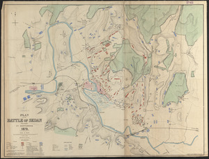
Plan of the battle of Sedan fought 1st September 1870
30.
Shepherd's map of the seat of war
31.
Topographical map of the seat of the war
32.
War map of Central Europe from Paris to Vienna
33.
Carl Jügel's post u. reise karte von Deutschland und den nachbar staaten, bis London, Paris, Montpellier, Florenz, Warschau,...
34.
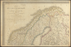
Carte de la Russie d'Europe, avec l'Empire d'Autriche, la Suede, le Danemark et la Norwege, la Prusse, le Grand Duche ́de...
35.
Charte von den Königreichen Preussen und Polen dem Grosherzogthum Posen nebst dem Gebiete der freien Stadt Krakau : nach dem...
36.
The Daily Telegraph war map no. 16
37.
Das Deutsche Reich : in 4 Blättern
38.
Deutschland
39.
Deutschland in seiner neugestaltung
40.
Deutschland nebst den königreichen Holland, Belgien und der republik Schweiz
‹ Prev
Next ›
1
2
3
4
5
6
…
434
435