Toggle navigation
LMEC Home
Exhibitions
Georeferencing
Tools for Teachers
Collections
My Favorites
Sign Up / Log In
Search
Search the map portal
Map Collection
Map Collection
Map Sets
Search
Search
Search for
Search In
All Fields
Creator
Title
Subject
Place
Search All Digital Collections
Advanced Search
8549 Results
My Search
Start Over
More Like
commonwealth:4m90fk33m
Remove constraint More Like: commonwealth:4m90fk33m
Filter your Search
Place
North and Central America
5,844
United States
4,769
Massachusetts
2,052
Europe
1,359
Suffolk (county)
1,034
Boston
1,007
Canada
448
Asia
421
more
Place
»
Topic
Boston (Mass.)--Maps
577
United States--Maps
273
Real property--Massachusetts--Boston--Maps
174
Massachusetts--Maps
160
Landowners--Massachusetts--Boston--Maps
132
North America--Maps--Early works to 1800
103
New England--Maps
99
Europe--Maps
78
more
Topic
»
Date
Date range begin
–
Date range end
Current results range from
1482
to
2023
View distribution
Creator
United States. Hydrographic Office
594
O.H. Bailey & Co
148
Des Barres, Joseph F. W. (Joseph Frederick Wallet), 1722-1824
123
United States. Post Office Dept
120
Ptolemy, 2nd cent
100
Walling, Henry Francis, 1825-1888
94
Geological Survey (U.S.)
86
Jefferys, Thomas, -1771
85
more
Creator
»
Format
Maps/Atlases
8,490
Manuscripts
215
Prints
56
Books
36
Objects/Artifacts
10
Drawings/Illustrations
8
Posters
4
Georeferenced
Yes
868
No
7,681
Collection
Norman B. Leventhal Map & Education Center Collection
8,549
Boston and New England Maps
2,204
Urban Maps
1,936
Maritime Charts and Atlases
1,081
American Revolutionary War-Era Maps
616
Boston Redevelopment Authority Collection
87
Available to use
No known restrictions
8,408
Creative Commons license
46
Search Constraints
Sort by relevance
relevance
title
date (asc)
date (desc)
Number of results to display per page
20 per page
10
per page
20
per page
50
per page
100
per page
View results as:
grid view
map view
Search Results
21.
West Indies, sheet no. Jamaica with Pedro and Rosalind Banks and with parts of Cuba and San Domingo : from British, Spanish and...
22.
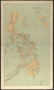
Carta general del Archipiélago Filipino
23.
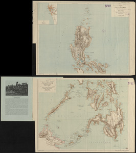
Chart of the Philippine Islands, from the Spanish chart 1808 : the adjacent islands are added from the latest surveys
24.
Eastern passages to China
25.
Geologic reconnaissance map of Mindanao
26.
Karte der Philippinen : in zwei sectionen : nördliches und südliches blatt
27.
Map of Philippine Islands and adjacent seas : from material of the English and Batavian governments
28.
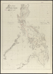
Map of the Philippine Islands and Sulu Archipelago
29.
Northern Philippines land utilization
30.
Philippine Islands : [outline map]
31.
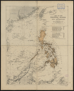
The Philippine Islands
32.
Philippine Islands radio stations and cables
33.
Ports in the Philippine Islands
34.
Progress map of Signal Corps telegraph lines & cables in the military division of the Philippines : based on map of Montero y...
35.
Progress map of Signal Corps telegraph lines & cables in the military division of the Philippines : based on map of Montero y...
36.
The 100th anniversary map of Abraham Lincoln's visit to Massachusetts, September 11-23, 1848
37.
1630 shoreline
38.
1879. Progress map of the U.S. Geographical Surveys west of the 100th Meridian : prepared under the direction of 1st Lieut....
39.
1903 Map of Salem and surrounding places
40.
19th annual convention of the National Association of Real Estate Boards : at Tulsa, June 7 to June 11 in 1926
‹ Prev
Next ›
1
2
3
4
5
6
…
427
428