Toggle navigation
LMEC Home
Exhibitions
Georeferencing
Tools for Teachers
Collections
My Favorites
Sign Up / Log In
Search
Search the map portal
Map Collection
Map Collection
Map Sets
Search
Search
Search for
Search In
All Fields
Creator
Title
Subject
Place
Search All Digital Collections
Advanced Search
8559 Results
My Search
Start Over
More Like
commonwealth:4m90f594v
Remove constraint More Like: commonwealth:4m90f594v
Filter your Search
Place
North and Central America
5,854
United States
4,778
Massachusetts
2,052
Europe
1,359
Suffolk (county)
1,034
Boston
1,007
Canada
448
Asia
422
more
Place
»
Topic
Boston (Mass.)--Maps
577
United States--Maps
273
Real property--Massachusetts--Boston--Maps
174
Massachusetts--Maps
160
Landowners--Massachusetts--Boston--Maps
132
North America--Maps--Early works to 1800
103
New England--Maps
99
Europe--Maps
78
more
Topic
»
Date
Date range begin
–
Date range end
Current results range from
1482
to
2023
View distribution
Creator
United States. Hydrographic Office
594
O.H. Bailey & Co
148
Des Barres, Joseph F. W. (Joseph Frederick Wallet), 1722-1824
123
United States. Post Office Dept
120
Ptolemy, 2nd cent
100
Walling, Henry Francis, 1825-1888
94
Geological Survey (U.S.)
86
Jefferys, Thomas, -1771
85
more
Creator
»
Format
Maps/Atlases
8,500
Manuscripts
215
Prints
56
Books
36
Objects/Artifacts
10
Drawings/Illustrations
8
Posters
4
Georeferenced
Yes
869
No
7,690
Collection
Norman B. Leventhal Map & Education Center Collection
8,559
Boston and New England Maps
2,204
Urban Maps
1,936
Maritime Charts and Atlases
1,081
American Revolutionary War-Era Maps
616
Boston Redevelopment Authority Collection
87
David Judkins Weaver Papers
10
Available to use
No known restrictions
8,418
Creative Commons license
46
Search Constraints
Sort by relevance
relevance
title
date (asc)
date (desc)
Number of results to display per page
20 per page
10
per page
20
per page
50
per page
100
per page
View results as:
grid view
map view
Search Results
21.
Frank Leslie's war maps and companion to the newspaper
22.
H.H. Lloyd & Co's campaign military charts showing the principal strategic places of interest
23.
Historical sketch of the rebellion
24.
The historical war map
25.
J.H. Colton's Topographical map of seat of war in Virginia, Maryland, &c
26.
Lloyd's new county map of the United States and Canadas showing battle fields, railroads, &c., compiled from the latest...
27.
Lloyd's new military map of the border & southern states
28.
Lloyd's new military map of the border & southern states
29.
Lloyd's new military map of the border & southern states
30.
Map illustrating the military operations in front of Atlanta, Ga : from the passage of Peach Tree Creek, July 19th, 1864, to...
31.
Map of Andersonville, Sumter Co., Georgia
32.
Map of southeastern portion of United States showing the location of battles in the Civil War 1861-1865
33.
Map of the seat of war : to accompany the American Conflict
34.
Map of the seat of war : containing a map of the vicinity of Washington, Baltimore, Harper's Ferry and Annapolis, with five...
35.
Map of the Southern States, showing the relative proportion of slaves in the different localities
36.
Military map of the middle and southern states showing the seat of war during the great rebellion in 1861
37.
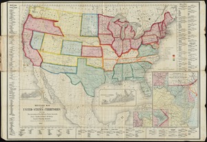
Military map of the United States & territories showing the location of the military posts, arsenals, Navy yards, & ports of...
38.
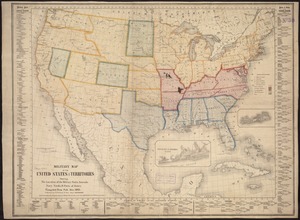
Military map of the United States & territories showing the location of the military posts, arsenals, Navy Yards, & ports of...
39.
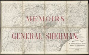
Military map showing the marches of the United States forces under command of Maj. Genl. W.T. Sherman, U.S.A. during the years...
40.
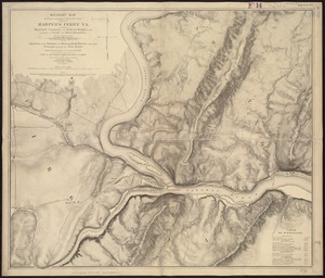
Military map showing the topographical features of the country adjacent to Harper's Ferry, Va : including Maryland, Loudoun,...
‹ Prev
Next ›
1
2
3
4
5
6
…
427
428