Toggle navigation
LMEC Home
Exhibitions
Georeferencing
Tools for Teachers
Collections
My Favorites
Sign Up / Log In
Search
Search the map portal
Map Collection
Map Collection
Map Sets
Search
Search
Search for
Search In
All Fields
Creator
Title
Subject
Place
Search All Digital Collections
Advanced Search
8721 Results
My Search
Start Over
More Like
commonwealth:3f462v011
Remove constraint More Like: commonwealth:3f462v011
Filter your Search
Place
North and Central America
5,950
United States
4,865
Massachusetts
2,084
Europe
1,396
Suffolk (county)
1,047
Boston
1,020
Canada
457
Asia
438
more
Place
»
Topic
Boston (Mass.)--Maps
586
United States--Maps
282
Real property--Massachusetts--Boston--Maps
175
Massachusetts--Maps
162
Landowners--Massachusetts--Boston--Maps
133
North America--Maps--Early works to 1800
104
New England--Maps
102
Europe--Maps
79
more
Topic
»
Date
Date range begin
–
Date range end
Current results range from
1482
to
2023
View distribution
Creator
United States. Hydrographic Office
595
O.H. Bailey & Co
148
Des Barres, Joseph F. W. (Joseph Frederick Wallet), 1722-1824
126
United States. Post Office Dept
120
Ptolemy, 2nd cent
100
Walling, Henry Francis, 1825-1888
94
Jefferys, Thomas, -1771
87
Geological Survey (U.S.)
86
more
Creator
»
Format
Maps/Atlases
8,661
Manuscripts
217
Prints
56
Books
36
Objects/Artifacts
10
Drawings/Illustrations
8
Posters
5
Georeferenced
Yes
870
No
7,851
Collection
Norman B. Leventhal Map & Education Center Collection
8,701
Boston and New England Maps
2,238
Urban Maps
2,024
Maritime Charts and Atlases
1,091
American Revolutionary War-Era Maps
635
Boston Redevelopment Authority Collection
87
Mapping Boston Collection
7
Richard H. Brown Revolutionary War Map Collection at Mount Vernon
5
more
Collection
»
Available to use
No known restrictions
8,554
Creative Commons license
67
Search Constraints
Sort by relevance
relevance
title
date (asc)
date (desc)
Number of results to display per page
20 per page
10
per page
20
per page
50
per page
100
per page
View results as:
grid view
map view
Search Results
1.
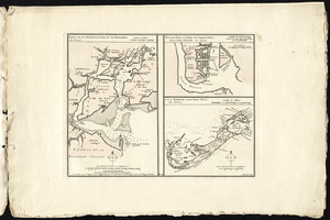
Particular draughts and plans of some of the principal towns and harbours belonging to the English, French, and Spaniards, in...
2.
New Found Land, St. Laurence Bay, the fishing banks, Acadia, and part of New Scotland
3.
Ports de la Nouvelle York et de Pertamboy -- Plan de la ville et du port de Charles Town dans la Caroline Méridionale -- I. de...
4.
Port Royal appellé aujourd. par les Anglois Annapolis Royal
5.
Chart of the entrance of Hudson's River, from Sandy Hook to New York, with the banks, depths of water, sailing-marks, & ca
6.
Canada orientale nell' America Settentrionale
7.
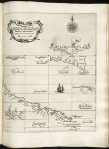
Carta particolare della Meta Incognita Australe con una parte della America Settentrionale
8.
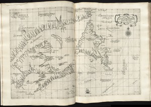
Carta particolare della terra nuoua con la Gran Baia et il Fiume Grande della Canida
9.
A Chart of the north part of America, describing the sea coast of Groenland, Dawies Streights, Baffins Bay, Hudsons Streights,...
10.
Chart of the Streights of Belle Isle
11.
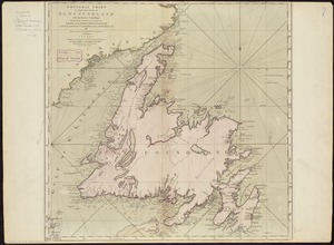
A general chart of the island of Newfoundland with the rocks & soundings
12.
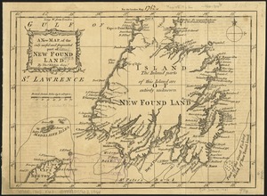
A new map of the only useful and frequented part of New Found Land
13.
Charles-town, capitale de la Caroline
14.
A chart of South Carolina and Georgia
15.
A chart of South Carolina and Georgia
16.
A chart of South Carolina and Georgia
17.
A general map of the southern British colonies in America comprehending North and South Carolina, Georgia, East and West...
18.
A new and general map of the Southern dominions belonging to the United States of America, viz North Carolina, South Carolina,...
19.
A new mapp of Carolina
20.
[A chart of Boston Bay and vicinity]
‹ Prev
Next ›
1
2
3
4
5
…
436
437


![[A chart of Boston Bay and vicinity]](https://bpldcassets.blob.core.windows.net/derivatives/images/commonwealth:cj82m2976/image_thumbnail_300.jpg)