Toggle navigation
LMEC Home
Exhibitions
Georeferencing
Tools for Teachers
Collections
My Favorites
Sign Up / Log In
Search
Search the map portal
Map Collection
Map Collection
Map Sets
Search
Search
Search for
Search In
All Fields
Creator
Title
Subject
Place
Search All Digital Collections
Advanced Search
8886 Results
My Search
Start Over
More Like
commonwealth:1257bp01s
Remove constraint More Like: commonwealth:1257bp01s
Filter your Search
Place
North and Central America
6,130
United States
5,048
Massachusetts
2,124
Europe
1,388
Suffolk (county)
1,282
Boston
1,255
Canada
449
Asia
436
more
Place
»
Topic
Boston (Mass.)--Maps
747
United States--Maps
279
Real property--Massachusetts--Boston--Maps
254
City planning--Massachusetts--Boston--Maps
208
Landowners--Massachusetts--Boston--Maps
170
Massachusetts--Maps
165
Urban renewal--Massachusetts--Boston--Maps
111
New England--Maps
103
more
Topic
»
Date
Date range begin
–
Date range end
Current results range from
1482
to
2023
View distribution
Creator
United States. Hydrographic Office
595
Boston Redevelopment Authority
209
O.H. Bailey & Co
148
Des Barres, Joseph F. W. (Joseph Frederick Wallet), 1722-1824
124
United States. Post Office Dept
120
Ptolemy, 2nd cent
100
Walling, Henry Francis, 1825-1888
94
Geological Survey (U.S.)
87
more
Creator
»
Format
Maps/Atlases
8,827
Manuscripts
215
Prints
56
Books
36
Objects/Artifacts
10
Drawings/Illustrations
8
Posters
4
Georeferenced
Yes
885
No
8,001
Collection
Norman B. Leventhal Map & Education Center Collection
8,668
Boston and New England Maps
2,399
Urban Maps
2,159
Maritime Charts and Atlases
1,083
American Revolutionary War-Era Maps
638
Boston Redevelopment Authority Collection
245
Massachusetts Real Estate Atlases
38
Mapping Boston Collection
20
more
Collection
»
Available to use
No known restrictions
8,663
Creative Commons license
70
Search Constraints
Sort by relevance
relevance
title
date (asc)
date (desc)
Number of results to display per page
20 per page
10
per page
20
per page
50
per page
100
per page
View results as:
grid view
map view
Search Results
8141.
This map of Scotland
8142.
This map of South America, according to the newest and most exact observations
8143.
This map presents a Bostonian's idea of the United States of America
8144.
This plan contains about 1000 acres, of the Canton Company's Land
8145.
This plan of the city of Philadelphia and it's [sic] environs, (shewing the improved parts,) is dedicated to the mayor,...
8146.
Three Rivers, Mass
8147.
Thunder Bay, Lake Huron
8148.
Thun-Interlaken
8149.
Tierra nveva
8150.
Tilton, N.H., Belknap County : 1884
8151.
The Times-Picayune's map of New Orleans
8152.
Title page of Theatrum Orbis Terrarum
8153.
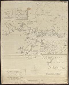
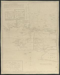
To Captain Krusenstern, of the Imperial Russian Navy, as a tribute for his laudable exertions to benefit navigation and...
8154.
To Captain Krusenstern, of the Imperial Russian Navy, as a tribute for his laudable exertions to benefit navigation and...
8155.
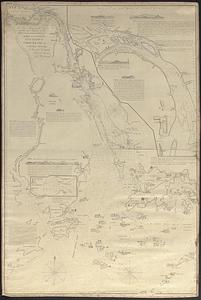
To Chas. Marjoribanks esqre. and the other members of the Honble. East India Company's factory at Canton, this chart of Choo...
8156.
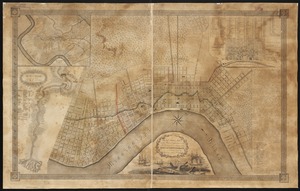
To General Andrew Jackson and his brave companions in arms on the 8th of Jany. 1815 this plan of the city of New Orleans is...
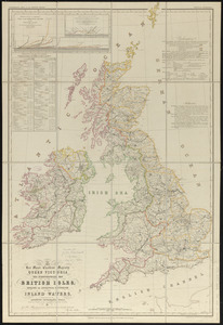
8157.
To her most excellent majesty Queen Victoria this hydrographical map of the British Isles, exhibiting the geographical...
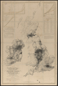
8158.
To her most excellent majesty Queen Victoria this map of the British Isles, elucidating the distribution of the population,...
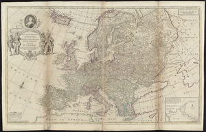
8159.
To Her most Sacred Majesty Carolina Queen of Great Britain, France & Ireland, this map of Europe, according to the newest and...
8160.
To his excellency the Count of Czernichew, Commander in Chief of her Majesty the Empress, of all the Russia's fleet and...
‹ Prev
Next ›
1
2
…
404
405
406
407
408
409
410
411
412
…
444
445


![This plan of the city of Philadelphia and it's [sic] environs, (shewing the improved parts,) is dedicated to the mayor, aldermen and citizens thereof](https://bpldcassets.blob.core.windows.net/derivatives/images/commonwealth:4m90fd11j/image_thumbnail_300.jpg)