Toggle navigation
LMEC Home
Exhibitions
Georeferencing
Tools for Teachers
Collections
My Favorites
Sign Up / Log In
Search
Search the map portal
Map Collection
Map Collection
Map Sets
Search
Search
Search for
Search In
All Fields
Creator
Title
Subject
Place
Search All Digital Collections
Advanced Search
8722 Results
My Search
Start Over
More Like
commonwealth:0r96fn93f
Remove constraint More Like: commonwealth:0r96fn93f
Filter your Search
Place
North and Central America
5,950
United States
4,870
Massachusetts
2,068
Europe
1,392
Suffolk (county)
1,042
Boston
1,014
Canada
464
Asia
437
more
Place
»
Topic
Boston (Mass.)--Maps
582
United States--Maps
327
Real property--Massachusetts--Boston--Maps
175
Massachusetts--Maps
161
Landowners--Massachusetts--Boston--Maps
133
North America--Maps--Early works to 1800
103
New England--Maps
101
Manuscript maps
84
more
Topic
»
Date
Date range begin
–
Date range end
Current results range from
1482
to
2023
View distribution
Creator
United States. Hydrographic Office
595
O.H. Bailey & Co
148
Des Barres, Joseph F. W. (Joseph Frederick Wallet), 1722-1824
123
United States. Post Office Dept
120
Ptolemy, 2nd cent
100
Walling, Henry Francis, 1825-1888
94
Geological Survey (U.S.)
87
Jefferys, Thomas, -1771
85
more
Creator
»
Format
Maps/Atlases
8,662
Manuscripts
241
Prints
56
Books
36
Objects/Artifacts
10
Drawings/Illustrations
8
Posters
5
Georeferenced
Yes
871
No
7,851
Collection
Norman B. Leventhal Map & Education Center Collection
8,657
Boston and New England Maps
2,221
Urban Maps
1,992
Maritime Charts and Atlases
1,083
American Revolutionary War-Era Maps
680
Boston Redevelopment Authority Collection
87
Library of Congress Collection
22
American Antiquarian Society Collection
20
more
Collection
»
Available to use
No known restrictions
8,510
Creative Commons license
75
Search Constraints
Sort by relevance
relevance
title
date (asc)
date (desc)
Number of results to display per page
20 per page
10
per page
20
per page
50
per page
100
per page
View results as:
grid view
map view
Search Results
161.
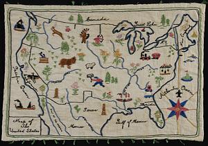
Map of the United States
162.
A map of the United States and Canada, New-Scotland, New-Brunswick and New-Foundland = Carte des Etats-Unis avec le Canada, la...
163.
Map of the United States and territories, showing the extent of public surveys and other details constructed from the plats and...
164.
Map of the United States and territories with adjacent parts of Canada and Mexico, also part of the West India Islands :...
165.
Map of the United States, British & Central America : from state documents & unpublished materials
166.
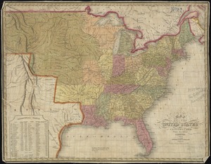
Map of the United States, constructed from the latest authorities
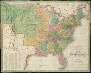
167.
Map of the United States, constructed from the latest authorities
168.
Map of the United States exhibiting the several collection districts
169.
Map of the United States, from the latest surveys : with the heights of mountains and length of the principle rivers
170.
A map of the United States, from the latest surveys : with the height of mountains and length of the principal rivers
171.
Map of the United States including Oregon, Texas and the Californias
172.
Map of the United States of America
173.
Map of the United States of America
174.
Map of the United States of America, Mexico, Central America, and the West India Islands
175.
Map of the United States of America, the British Provinces, Mexico, the West Indies and Central America, with part of New...
176.
Map of the United States of America, the British provinces, Mexico, the West Indies and Central America, with part of New...
177.
Map of the United States of North America
178.
A map of the United States of North America : drawn from a number of critical researches
179.
Map of the United States of North America, upper & lower Canada, New Brunswick, Nova Scotia & British Columbia, Mexico, Cuba,...
180.
Map of the United States, showing by colors the area of freedom and slavery, and the territories whose destiny is yet to be...
‹ Prev
Next ›
1
2
…
5
6
7
8
9
10
11
12
13
…
436
437