Toggle navigation
LMEC Home
Exhibitions
Georeferencing
Tools for Teachers
Collections
My Favorites
Sign Up / Log In
Search
Search the map portal
Map Collection
Map Collection
Map Sets
Search
Search
Search for
Search In
All Fields
Creator
Title
Subject
Place
Search All Digital Collections
Advanced Search
27 Results
My Search
Start Over
More Like
commonwealth:z603vs51b
Remove constraint More Like: commonwealth:z603vs51b
Place
Canada
Remove constraint Place: Canada
Filter your Search
Place
Canada
[remove]
27
North and Central America
27
Québec
7
United States
7
Nova Scotia
5
Louisbourg
4
New England
3
Saint Lawrence River
3
more
Place
»
Topic
United States--History--French and Indian War, 1754-1763--Maps--Early works to 1800
5
Louisbourg (N.S.)--History--Siege, 1758--Maps--Early works to 1800
4
Canada--History--Revolution, 1775-1783--Maps--Early works to 1800
3
Canada--Maps--Early works to 1800
3
Québec (Province)--Maps--Early works to 1800
3
Québec (Québec)--Maps--Early works to 1800
3
United States--Maps--Early works to 1800
3
Acadia--Maps--Early works to 1800
2
more
Topic
»
Date
Date range begin
–
Date range end
Current results range from
1745
to
1784
1745 : 1785
1745
1785
View distribution
Creator
Korn, Christoph Heinrich, 1726-1783
3
Raspe, Gabriel Nicolaus, 1712-1785
3
Sayer, Robert, 1725-1794
3
Smyth, Hervey, 1734-1811
3
Dury, Andrew
2
Faden, William, 1749-1836
2
Heiden, Christian Friedrich von der
2
Keulen, Gerard van
2
more
Creator
»
Format
Maps/Atlases
23
Prints
4
Manuscripts
3
Georeferenced
Yes
1
No
26
Collection
American Revolutionary War-Era Maps
27
Richard H. Brown Revolutionary War Map Collection at Mount Vernon
27
Available to use
Creative Commons license
27
Search Constraints
Sort by relevance
relevance
title
date (asc)
date (desc)
Number of results to display per page
20 per page
10
per page
20
per page
50
per page
100
per page
View results as:
grid view
map view
Search Results
1.
Carte du Canada et des Etats-Unis de l'Amérique Septentrionale
2.
Carte du theatre de la guerre presente en Amerique
3.
Carte d'une partie du Nord Amerique dans la quelle se trouvent les isles et les provinces suivantes : l'Isle de la Terre-Neuve...
4.
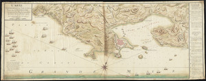
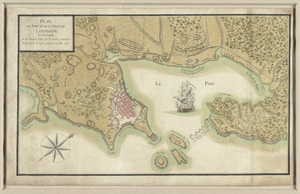
Carte topographique du port et de la ville de Louisbourg, assiegé par les Anglais pendant les mois de Juin, Juillet 1758
5.
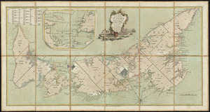
The coast of New Schotland, New England, the gulph and river of St. Laurence : the islands of New Foundland, Cape Breton, St....
6.
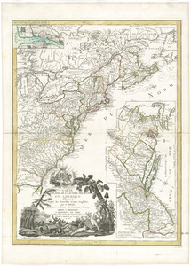
A general map of the middle British colonies, in America : viz Virginia, Màriland, Dèlaware, Pensilvania, New-Jersey,...
7.
Karte von dem Ostlichen-Stucke von Neu Franckreich oder Canada in America : besonders aber Acadia und Neu Schottland
8.
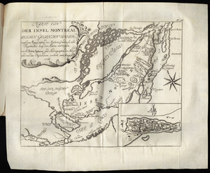
Karte von der Insel Montreal und den gegenden umher, nach den manuscripten der karten, grundrisse und tagebücher beÿ der...
9.
Lauff des flusses St. Laurentzi von Quebec bis an den See Ontario : 2. bladt
10.
Map of Nova Scotia, or Acadia : with the islands of Cape Breton and St. John's, from actual surveys
11.
A map of the inhabited part of Canada from the French surveys : with the frontiers of New York and New England from the large...
12.
A new and accurate map of the English empire in North America : representing their rightful claim as confirmed by charters, and...
13.
A new chart of the coast of New England, Nova Scotia, and the islands of St. John, Cape Breton, Sable, the banks of St. Peters,...
14.
A new map of Nova Scotia, and Cape Britain : with the adjacent parts of New England and Canada, composed from a great number of...
15.
Plan de la ville de Louisbourg avec les ouvrages d'attaque des Anglais pour sa reddition, ainsi que ceux des assiegés pr. la...
16.
Plan du fort et ville de Louisbourg dans l'Isle Roale
17.
Plan du port et de la ville de Louisbourg en l'Isle Royale, et des attaques faites par les Anglois pendant le siége dépuis le...
18.
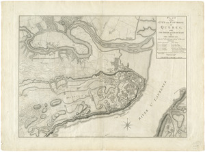
Plan of the city and environs of Quebec, with its siege and blockade by the Americans, from the 8th of December 1775 to the...
19.
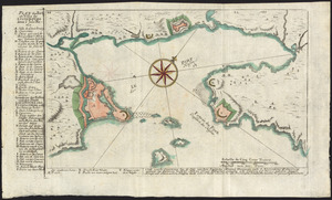
A plan of the island of St. John with the divisions of the counties, parishes, & the lots as granted by government, likewise...
20.
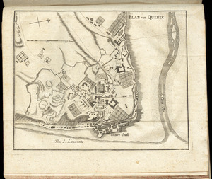
Plan von Quebec
+
-
Redo search here
Search when I move the map
Leaflet
| ©
OpenStreetMap
contributors, ©
CartoDB
‹ Prev
Next ›
1
2