Toggle navigation
LMEC Home
Exhibitions
Georeferencing
Tools for Teachers
Collections
My Favorites
Sign Up / Log In
Search
Search the map portal
Map Collection
Map Collection
Map Sets
Search
Search
Search for
Search In
All Fields
Creator
Title
Subject
Place
Search All Digital Collections
Advanced Search
57 Results
My Search
Start Over
More Like
commonwealth-oai:v405x789b
Remove constraint More Like: commonwealth-oai:v405x789b
Available to use
No known restrictions
Remove constraint Available to use: No known restrictions
Filter your Search
Place
North and Central America
57
United States
57
Rhode Island
45
Massachusetts
32
Connecticut
19
New England
8
Boston
4
Suffolk (county)
4
more
Place
»
Topic
Rhode Island--Maps
43
Massachusetts--Maps
28
Connecticut--Maps
21
Railroads--Massachusetts--Maps
10
Railroads--Rhode Island--Maps
10
United States--History--Revolution, 1775-1783--Maps
10
New England--Maps
9
Railroads--Connecticut--Maps
7
more
Topic
»
Date
Date range begin
–
Date range end
Current results range from
1777
to
1981
1777 : 1982
1777
1982
View distribution
Creator
Geological Survey (U.S.)
5
Carey, Mathew, 1760-1839
2
Harris, Harding.
2
Rhode Island
2
Annin & Smith
1
Atwater, S.
1
Barker, W. (William), active 1795-1803
1
Bauman, Sebastian
1
more
Creator
»
Format
Maps/Atlases
57
Manuscripts
1
Objects/Artifacts
1
Georeferenced
Yes
13
No
44
Collection
Norman B. Leventhal Map & Education Center Collection
55
Boston and New England Maps
42
American Revolutionary War-Era Maps
7
David Judkins Weaver Papers
4
Urban Maps
3
Maritime Charts and Atlases
2
New-York Historical Society Collection
2
Applied Geographics, Inc. Records
1
Available to use
No known restrictions
[remove]
57
Search Constraints
Sort by relevance
relevance
title
date (asc)
date (desc)
Number of results to display per page
20 per page
10
per page
20
per page
50
per page
100
per page
View results as:
grid view
map view
Search Results
1.
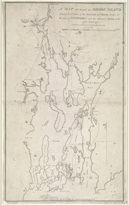
A map of part of Rhode Island shewing the positions of the American and British armies at the Siege of Newport, and the...
2.
Chart of Narraganset Bay : surveyed in 1832
3.
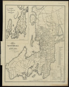
Map of Newport, R.I
4.
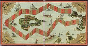
The Newport yacht race : an exciting game
5.
74 miles on the ocean scenic highway U.S. 1
6.
The city of New York as laid out by the Commissioners with the surrounding country
7.
Coast of the United States, from New York to Cape Ann : drawn from the U.S. Coast Surveys
8.
Colton's Massachusetts and Rhode Island
9.
Connecticut with portions of New York & Rhode Island
10.
Explorer's map & directory of the New England Coast : New London, Connecticut, to Passamaquoddy Bay, Canada : a comprehensive...
11.
Geographical, statistical, and historical map of Rhode Island
12.
Hammond's new road map of Rhode Island and southeastern Massachusetts
13.
Johnson's Massachusetts Connecticut and Rhode Island
14.
Manuscript maps of U.S. states
15.
Map of Massachusetts and Rhode Island
16.
Map of Massachusetts, Connecticut and Rhode Island constructed from the latest authorities
17.
Map of Massachusetts, Connecticut and Rhode Island constructed from the latest authorities
18.
Map of Massachusetts, Connecticut and Rhode Island constructed from the latest authorities
19.
A map of Massachusetts, Connecticut and Rhodeisland
20.
Map of Massachusetts, Rhode-Island & Connecticut : compiled from the latest authorities
‹ Prev
Next ›
1
2
3