Toggle navigation
LMEC Home
Exhibitions
Georeferencing
Tools for Teachers
Collections
My Favorites
Sign Up / Log In
Search
Search the map portal
Map Collection
Map Collection
Map Sets
Search
Search
Search for
Search In
All Fields
Creator
Title
Subject
Place
Search All Digital Collections
Advanced Search
8551 Results
My Search
Start Over
More Like
commonwealth:ht250515q
Remove constraint More Like: commonwealth:ht250515q
Available to use
No known restrictions
Remove constraint Available to use: No known restrictions
Filter your Search
Place
North and Central America
5,810
United States
4,729
Massachusetts
2,040
Europe
1,393
Suffolk (county)
1,018
Boston
992
Canada
449
Asia
425
more
Place
»
Topic
Boston (Mass.)--Maps
574
United States--Maps
209
Real property--Massachusetts--Boston--Maps
173
Massachusetts--Maps
154
Landowners--Massachusetts--Boston--Maps
132
North America--Maps--Early works to 1800
103
New England--Maps
102
Europe--Maps
79
more
Topic
»
Date
Date range begin
–
Date range end
Current results range from
1482
to
2022
1482 : 2023
1482
2023
View distribution
Creator
United States. Hydrographic Office
595
O.H. Bailey & Co
148
Des Barres, Joseph F. W. (Joseph Frederick Wallet), 1722-1824
123
United States. Post Office Dept
120
Ptolemy, 2nd cent
100
Walling, Henry Francis, 1825-1888
94
Geological Survey (U.S.)
86
Jefferys, Thomas, -1771
84
more
Creator
»
Format
Maps/Atlases
8,491
Manuscripts
215
Prints
56
Books
35
Objects/Artifacts
10
Drawings/Illustrations
8
Posters
5
Georeferenced
Yes
836
No
7,715
Collection
Norman B. Leventhal Map & Education Center Collection
8,551
Boston and New England Maps
2,196
Urban Maps
2,007
Maritime Charts and Atlases
1,082
American Revolutionary War-Era Maps
613
Boston Redevelopment Authority Collection
87
Available to use
No known restrictions
[remove]
8,551
Search Constraints
Sort by relevance
relevance
title
date (asc)
date (desc)
Number of results to display per page
20 per page
10
per page
20
per page
50
per page
100
per page
View results as:
grid view
map view
Search Results
1.
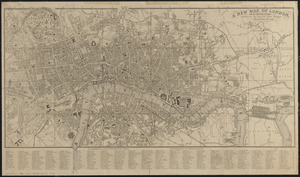
The Builder map of the county of London : shewing the boundaries of the surveyors' districts under the building acts
2.
The Builder map of the county of London : shewing the boundaries of the surveyors' districts under the building acts
3.
Civitas Londinum ano. dmi. circiter MDLX
4.
Clue plan for Collins' illustrated guide to London
5.
Cook's literary and historical map of London
6.
Cruchley's new plan of London shewing all the new and intended improvements to the present time
7.
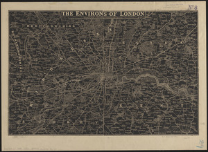
The environs of London : reduced from the Ordnance Survey
8.
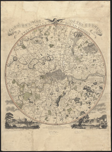
Fairburn's map of the country twelve miles round London
9.
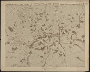
Illustrated map of London, or stranger's guide to the public buildings, theatres, music halls, & and all places of interest
10.
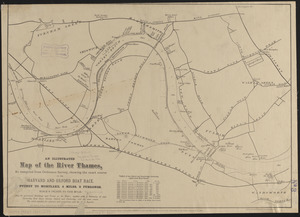
An illustrated map of the River Thames, as compiled from Ordnance Survey, showing the exact course of the Harvard and Oxford...
11.
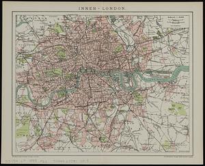
Inner-London
12.
Kelly's map of the suburbs of London
13.
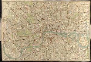
London
14.
London : guide to the International Exhibition, 1862
15.
London
16.
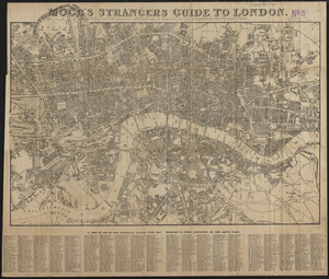
Mogg's strangers guide to London : exhibiting all the various alterations & improvements complete to the present time
17.
A new and accurate plan of London, Westminster and the Borough of Southwark, with all the additional streets, squares, &c :...
18.
New map of central London divided into quarter mile squares
19.
A new map of London, and the adjacent villages including the new streets and public buildings : corrected to 1836
20.
New plan of London
‹ Prev
Next ›
1
2
3
4
5
…
427
428