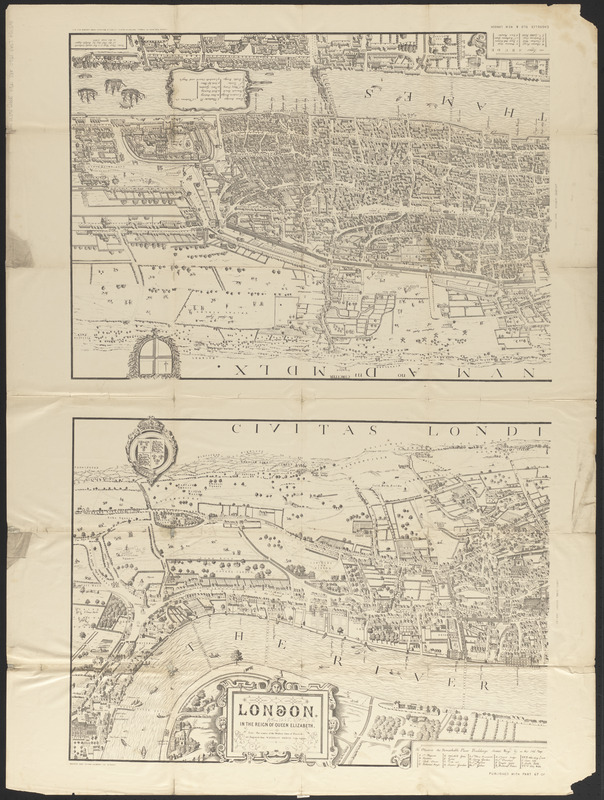
Civitas Londinum ano. dmi. circiter MDLX
Item Information
- Title:
- Civitas Londinum ano. dmi. circiter MDLX
- Title (alt.):
-
London in the reign of Queen Elizabeth
Old and new London : a narrative of its history, its people, and its places
- Cartographer:
- Agas, Ralph, 1545-1621
- Publisher:
- Cassell, Petter & Galpin
- Name on Item:
-
Ralph Aggas
- Date:
-
[1860–1869]
- Format:
-
Maps/Atlases
- Location:
-
Boston Public Library
Norman B. Leventhal Map & Education Center - Collection (local):
-
Norman B. Leventhal Map & Education Center Collection
- Subjects:
-
London (England)--History--16th century--Maps
London (England)--History--16th century--Aerial views
London (England)--Maps
- Places:
-
EnglandLondon
- Extent:
- 1 map in 2 sections ; sections 45 x 62 cm, on sheet 101 x 77 cm
- Terms of Use:
-
No known copyright restrictions.
No known restrictions on use.
- Publisher:
-
London :
Cassell, Petter & Galpin
- Scale:
-
Scale not given
- Language:
-
English
- Notes:
-
Bird's-eye view.
"Published with part 67 of Cassell's Old & New London."
"Note: This map is a facsimile (reduced) of the old one by Ralph Aggas in the year 1560."
- Notes (date):
-
This date is inferred.
- Identifier:
-
06_01_014896
- Call #:
-
G5754.L7A3 1560 .A33 1860
- Barcode:
-
39999065707448


