Toggle navigation
LMEC Home
Exhibitions
Georeferencing
Tools for Teachers
Collections
My Favorites
Sign Up / Log In
Search
Search the map portal
Map Collection
Map Collection
Map Sets
Search
Search
Search for
Search In
All Fields
Creator
Title
Subject
Place
Search All Digital Collections
Advanced Search
91 Results
My Search
Start Over
More Like
commonwealth:q524n452p
Remove constraint More Like: commonwealth:q524n452p
Creator
Jefferys, Thomas, -1771
Remove constraint Creator: Jefferys, Thomas, -1771
Filter your Search
Place
North and Central America
72
United States
24
North America
12
Canada
10
South America
8
Cuba
6
Quebec
6
West Indies
6
more
Place
»
Topic
North America--Maps--Early works to 1800
12
America--Discovery and Exploration--Maps--Early works to 1800
6
Québec (Québec)--Maps--Early works to 1800
4
Saint Lawrence River--Maps--Early works to 1800
4
West Indies--Maps--Early works to 1800
4
Atlantic Ocean--Maps--Early works to 1800
3
Basse-Terre (Guadeloupe)--Maps--Early works to 1800
3
Québec Campaign, Québec, 1759--Maps--Early works to 1800
3
more
Topic
»
Date
Date range begin
–
Date range end
Current results range from
1735
to
1859
1735 : 1860
1735
1860
View distribution
Creator
Jefferys, Thomas, -1771
[remove]
91
Sayer, Robert, 1725-1794
67
Celi, Francisco Mathias
8
Green, John, -1757
7
Bully, le sieur
2
Caylus, de, engineer
2
Evans, Lewis, 1700?-1756
2
Faden, William, 1749-1836
2
more
Creator
»
Format
Maps/Atlases
91
Georeferenced
Yes
1
No
90
Collection
Norman B. Leventhal Map & Education Center Collection
84
American Revolutionary War-Era Maps
58
Maritime Charts and Atlases
20
New York Public Library Collection
3
Boston and New England Maps
2
MacLean Collection Map Library
2
Urban Maps
2
British Library Collection
1
more
Collection
»
Available to use
No known restrictions
83
Creative Commons license
6
Search Constraints
Sort by relevance
relevance
title
date (asc)
date (desc)
Number of results to display per page
20 per page
10
per page
20
per page
50
per page
100
per page
View results as:
grid view
map view
Search Results
1.
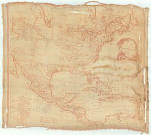
An accurate map of North America : describing and distinguishing the British, Spanish and French dominions on this great...
2.
Chart of the Atlantic Ocean, with the British, French, & Spanish settlements in North America, and the West Indies : as also on...
3.
Chart of the Atlantic Ocean, with the British, French, & Spanish settlements in North America, and the West Indies : as also on...
4.
A map of the discoveries made by the Russians on the North West coast of America
5.
A map of the n.e. part of Asia, and n.w. parts of America, shewing their situations with respect to Japan
6.
Chart of the Atlantic Ocean, with the British, French, & Spanish settlements in North America, and the West Indies : as also on...
7.
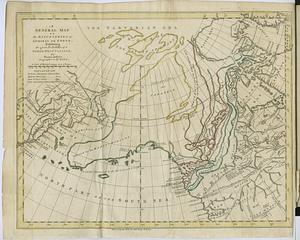
A general map of the discoveries of Admiral de Fonte, exhibiting the great probability of a north-west passage
8.
A general map of the middle British colonies in America : Viz. Virginia, Maryland, Delaware, Pensilvania, New-Jersey, New-York,...
9.
A map of North America
10.
A MAP of the BRITISH COLONIES in North America : WITH THE Roads, Distances, Limits, and Extent of the SETTLEMENTS, Humbly...
11.
North America
12.
North America
13.
An accurate map of His Majesty's province of New-Hampshire in New England : taken from actual surveys of all the inhabited...
14.
Antigoa
15.
An authentic plan of the River St. Laurence from Sillery to the fall of Montmorenci, with the operations of the siege of Quebec...
16.
An authentic plan of the town and harbour of Cap-François in the isle of St. Domingo
17.
The Caribbee Islands and Guayana
18.
Carte d'une partie de l'Amérique Septentrionale : pour servir à l'intellegence du mémoire sur les prétentions des Anglois...
19.
Chart comprizing Greenland with the countries and islands about Baffin's and Hudson's Bays
20.
Chart containing part of the Icy Sea with the adjacent coast of Asia and America
‹ Prev
Next ›
1
2
3
4
5