Toggle navigation
LMEC Home
Exhibitions
Georeferencing
Tools for Teachers
Collections
My Favorites
Sign Up / Log In
Search
Search the map portal
Map Collection
Map Collection
Map Sets
Search
Search
Search for
Search In
All Fields
Creator
Title
Subject
Place
Search All Digital Collections
Advanced Search
7825 Results
My Search
Start Over
More Like
commonwealth:2514p0642
Remove constraint More Like: commonwealth:2514p0642
Georeferenced
No
Remove constraint Georeferenced: No
Filter your Search
Place
North and Central America
5,228
United States
4,207
Massachusetts
1,832
Europe
1,315
Suffolk (county)
923
Boston
903
Canada
438
Asia
399
more
Place
»
Topic
Boston (Mass.)--Maps
506
United States--Maps
219
Real property--Massachusetts--Boston--Maps
168
Landowners--Massachusetts--Boston--Maps
128
Massachusetts--Maps
107
North America--Maps--Early works to 1800
102
New England--Maps
85
World maps
71
more
Topic
»
Date
Date range begin
–
Date range end
Current results range from
1482
to
2023
1482 : 2024
1482
2024
View distribution
Creator
United States. Hydrographic Office
594
O.H. Bailey & Co
148
Des Barres, Joseph F. W. (Joseph Frederick Wallet), 1722-1824
119
Ptolemy, 2nd cent
100
Walling, Henry Francis, 1825-1888
86
Jefferys, Thomas, -1771
84
Jansson, Jan, 1588-1664
75
Geological Survey (U.S.)
71
more
Creator
»
Format
Maps/Atlases
7,765
Manuscripts
200
Prints
56
Books
36
Objects/Artifacts
10
Drawings/Illustrations
8
Posters
5
Georeferenced
No
[remove]
7,825
Collection
Norman B. Leventhal Map & Education Center Collection
7,825
Boston and New England Maps
2,024
Urban Maps
1,852
Maritime Charts and Atlases
1,073
American Revolutionary War-Era Maps
581
Boston Redevelopment Authority Collection
87
Available to use
No known restrictions
7,716
Creative Commons license
40
Search Constraints
Sort by relevance
relevance
title
date (asc)
date (desc)
Number of results to display per page
20 per page
10
per page
20
per page
50
per page
100
per page
View results as:
grid view
map view
Search Results
1.
Chart of the track of the Dolphin, Tamar, Swallow & Endeavour through the South Seas ; & of the track of M. Bougainville round...
2.
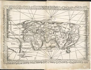
Ævi veteris usque ad annum salutis nonagesimum supra milles quadringentos cogniti tantum, typus geographica
3.
A map of the world on a globular projection : exhibiting particularly the nautical researches of Captain James Cook, F.R.S. :...
4.
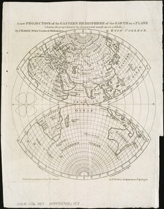
A new projection of the Eastern Hemisphere of the earth on a plane : shewing the proportions of its several parts nearly as on...
5.
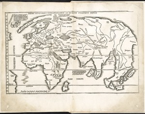
Orbis typus universalis iuxta hydrographorum traditionem exactissime depicta 1522 L.F
6.
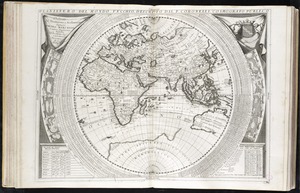
Planisfero del mondo vecchio
7.
Tabula moder. Gronlandiae et Russiae
8.
[The World]
9.
The 100th anniversary map of Abraham Lincoln's visit to Massachusetts, September 11-23, 1848
10.
19th annual convention of the National Association of Real Estate Boards : at Tulsa, June 7 to June 11 in 1926
11.
2005 significant U.S. hurricane strikes
12.
The 2100 project : an atlas for the Green New Deal
13.
227 Harzgerode
14.
305 Glatz
15.
38,000,000 escaped -- 10,000,000 died
16.
660 Wakulah St., Roxbury
17.
74 miles on the ocean scenic highway U.S. 1
18.
Aaron Bohrod's America, its history
19.
Aboriginal map of North America, denoting the boundaries and the locations of various Indian tribes
20.
Acapulco, México
‹ Prev
Next ›
1
2
3
4
5
…
391
392


![[The World]](https://bpldcassets.blob.core.windows.net/derivatives/images/commonwealth:9g54xj67p/image_thumbnail_300.jpg)


