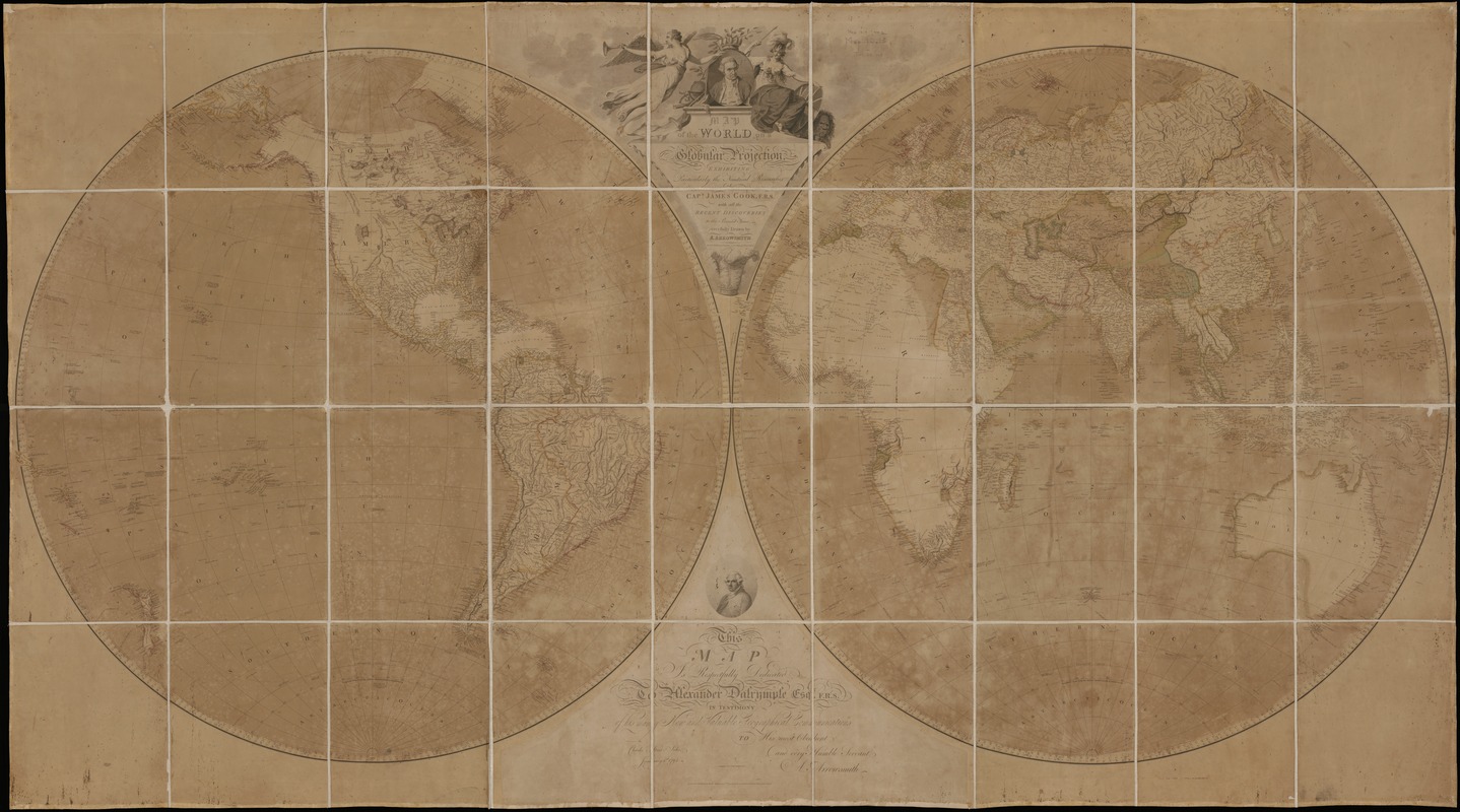
A map of the world on a globular projection : exhibiting particularly the nautical researches of Captain James Cook, F.R.S. : with all the recent discoveries to the present time
This map is also available in American Revolutionary Geographies Online (ARGO), a collections portal especially built for material relating to the American Revolutionary War Era. Visit ARGO to learn more about this item and explore the historical geography of North America in the late eighteenth century.
Item Information
- Title:
- A map of the world on a globular projection : exhibiting particularly the nautical researches of Captain James Cook, F.R.S. : with all the recent discoveries to the present time
- Description:
-
Arrowsmith, a prominent English map maker and publisher, had a reputation for producing accurate and updated maps. His world map published in 1794 specifically delineated the voyages of Capt. James Cook during the 1770s and according to the title, purported to include "all the recent discoveries to the present time." Reflecting the accumulated knowledge gained from 18th-century voyages and explorations, the map provided a fairly good outline of all the continents, except for the Arctic coastline of North America. Unlike many of his 17th-century predecessors, Arrowsmith did not provide fictional information for unexplored areas or fill blank spaces with monsters or fanciful animals. Consequently, no continental land mass was indicated within the southern polar region and California was no longer shown as an island. In addition, the interior portions of western North America, Africa, and Australia were still relatively void of detail, setting the stage for further exploration during the 19th century. In designing this map, Arrowsmith used the double hemisphere projection, which he labeled a globular projection, a term that is still used today to designate this type of projection. In contrast to his 17th- and 18th-century predecessors, he left the areas outside the spheres entirely blank except for minimal embellishments of the title cartouche at the top center. This cartouche included exquisite calligraphy and a globe next to the portrait of Cook. In addition, the dedication at the bottom center was placed below a portrait of Alexander Dalrymple, who was just appointed director of the newly-founded British Hydrographical Office and to whom the map was dedicated.
- Creator:
- Arrowsmith, Aaron, 1750-1823
- Date:
-
1794
- Format:
-
Maps/Atlases
- Location:
-
Boston Public Library
Norman B. Leventhal Map & Education Center - Collection (local):
-
Norman B. Leventhal Map & Education Center Collection
- Subjects:
-
World maps--Early works to 1800
Western Hemisphere--Maps--Early works to 1800
Eastern Hemisphere--Maps--Early works to 1800
- Places:
-
World
- Extent:
- 1 map on 4 sheets : hand col. ; 105 x 188 cm.
- Terms of Use:
-
No known copyright restrictions.
No known restrictions on use.
- Publisher:
-
London :
Published ... by A. Arrowsmith, geographer, No. 10 Soho Square
- Scale:
-
Scale [ca. 1:22,000,000. At equator]
- Language:
-
English
- Notes:
-
Relief shown by hachures.
"Published as the Act directs ..."
This large wall map, printed on four sheets, was published by Aaron Arrowsmith, one of the most respected British map makers during the late 18th and early 19th centuries. He had a reputation for collecting the latest and most accurate information which he used to compile incredibly detailed maps. On this map, he not only showed the coastal outlines and political administration of the West Indian islands and adjoining mainland territories, but he also listed variant place names for many of the major features, included place names for many smaller features such as banks or cays, displayed depth soundings in coastal areas as an aid to navigation, and portrayed the mountainous island interiors and mountain ranges of Mexico and Central America with a pictorial shading, suggesting a very rugged terrain. He also provided informative notes, often indicating the location of historical events such as Columbus' first landfall, or sources of information for particular geographic features. As with his other cartographic publications, Arrowsmith provided the most up-to-date information about one of the most contentious parts of the world at the beginning of the 19th century.
Variant of Phillips 1096.
Exhibited in “Journeys of the Imagination,” at the Boston Public Library, Boston, MA, April - August 2006. MB (BRL)
- Identifier:
-
05_01_000225
- Call #:
-
G3200 1794 .A77
- Barcode:
-
39999052507231
![[The World]](https://bpldcassets.blob.core.windows.net/derivatives/images/commonwealth:9g54xj67p/image_thumbnail_300.jpg)