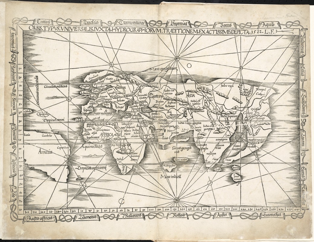
Orbis typus universalis iuxta hydrographorum traditionem exactissime depicta 1522 L.F
Item Information
- Title:
- Orbis typus universalis iuxta hydrographorum traditionem exactissime depicta 1522 L.F
- Creator:
- Fries, Lorenz, ca. 1490-1531
- Date:
-
1525
- Format:
-
Maps/Atlases
- Location:
-
Boston Public Library
Norman B. Leventhal Map & Education Center - Collection (local):
-
Norman B. Leventhal Map & Education Center Collection
- Subjects:
-
Eastern Hemisphere--Maps--Early works to 1800
- Places:
-
Europe
Asia
Africa
Oceania
Europe
Africa
Asia
Oceania
- Extent:
- 1 map ; 28 x 45 cm.
- Terms of Use:
-
No known copyright restrictions.
No known restrictions on use.
- Publisher:
-
Argentoragi [i.e. Strasbourg] :
Iohannes Grieningerus
- Scale:
-
Scale [ca. 1:80,000,000]
- Language:
-
Latin
- Notes:
-
Map of the eastern hemisphere showing Europe, Asia, Africa, and part of South America.
Reduced version of the corresponding map in Waldseemüller's atlas of 1513.
Relief shown pictorially.
Includes names of places and natural features.
Fries' map is the first world map in an edition of Ptolemy to include the name America.
Appears in the author's Geographia, translated by Willibald Pirckheimer, with annotations by Joannes Regiomontanus. Argentoragi [i.e. Strasbourg] : Iohannes Grieningerus, communibus Iohannis Koberger impensis excudebat, anno a Christi Natiuitate 1525 tertio Kal[endas] Apriles.
Text in Latin.
Cataloging, conservation, and digitization made possible in part by The National Endowment for the Humanities: Exploring the human endeavor.
Atlas scanned by Internet Archive http://archive.org/details/claudiiptolemaei00ptol
- Identifier:
-
06_01_008021
- Call #:
-
G1005 .P7 1525
- Barcode:
-
30000003788994