Toggle navigation
LMEC Home
Exhibitions
Georeferencing
Tools for Teachers
Collections
My Favorites
Sign Up / Log In
Search
Search the map portal
Map Collection
Map Collection
Map Sets
Search
Search
Search for
Search In
All Fields
Creator
Title
Subject
Place
Search All Digital Collections
Advanced Search
20 Results
My Search
Start Over
More Like
commonwealth:j3860815p
Remove constraint More Like: commonwealth:j3860815p
Collection
Applied Geographics, Inc. Records
Remove constraint Collection: Applied Geographics, Inc. Records
Filter your Search
Place
North and Central America
20
United States
20
Massachusetts
19
Canada
1
Hingham
1
Hull
1
New England
1
Passamaquoddy
1
more
Place
»
Topic
Massachusetts--Maps
20
Massachusetts--Photomaps--Indexes
4
Watersheds--Massachusetts--Maps
4
Coasts--Massachusetts--Maps
3
Coastal zone management--Massachusetts--Maps
2
Land use--Massachusetts--Maps
2
Protected areas--Massachusetts--Maps
2
Water-supply--Massachusetts--Maps
2
more
Topic
»
Date
Date range begin
–
Date range end
Current results range from
1981
to
2006
1981 : 2007
1981
2007
View distribution
Creator
MassGIS (Office : Mass.)
12
Applied Geographics, Inc.
7
Massachusetts. Executive Office of Environmental Affairs
5
Massachusetts Coastal Zone Management Office
4
Bliven, Steve
1
Gowell, Elizabeth Tayntor
1
Great Circle Productions (Firm)
1
Harris, Cynthia, 1957-
1
more
Creator
»
Format
Maps/Atlases
20
Georeferenced
No
20
Collection
Applied Geographics, Inc. Records
[remove]
20
Boston and New England Maps
20
Norman B. Leventhal Map & Education Center Collection
20
David Judkins Weaver Papers
1
Available to use
No known restrictions
20
Search Constraints
Sort by relevance
relevance
title
date (asc)
date (desc)
Number of results to display per page
20 per page
10
per page
20
per page
50
per page
100
per page
View results as:
grid view
map view
Search Results
1.
DFWELE land showing 1985-1990 acquisitions
2.
Eastern encephalitis risk area
3.
EOEA wide area network
4.
Executive Office of Environmental Affairs location of offices
5.
Explorer's map & directory of the New England Coast : New London, Connecticut, to Passamaquoddy Bay, Canada : a comprehensive...
6.
Human uses in the coastal zone : comprehensive database assembly July 2006
7.
Massachusetts Bays Program community resource atlas
8.
Massachusetts coastal towns
9.
Massachusetts coastal watersheds
10.
Massachusetts coastal zone management
11.
Massachusetts CZM shoreline change analysis project
12.
Massachusetts navigation and dredging management study
13.
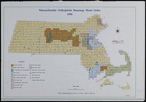
Massachusetts orthophoto basemap sheet index
14.
Massachusetts orthophoto basemap sheet index
15.
Massachusetts watersheds land use
16.
Orthophoto index
17.
Orthophoto quads index
18.
DEM protected open space
19.
Wellhead protection areas in southeastern Massachusetts
20.
Wellhead protection areas in southeastern Massachusetts
+
-
Redo search here
Search when I move the map
Leaflet
| ©
OpenStreetMap
contributors, ©
CartoDB