Toggle navigation
LMEC Home
Exhibitions
Georeferencing
Tools for Teachers
Collections
My Favorites
Sign Up / Log In
Search
Search the map portal
Map Collection
Map Collection
Map Sets
Search
Search
Search for
Search In
All Fields
Creator
Title
Subject
Place
Search All Digital Collections
Advanced Search
632 Results
My Search
Start Over
More Like
commonwealth:cj82m425c
Remove constraint More Like: commonwealth:cj82m425c
Collection
American Revolutionary War-Era Maps
Remove constraint Collection: American Revolutionary War-Era Maps
Filter your Search
Place
North and Central America
574
United States
353
Canada
108
Massachusetts
83
North America
75
Nova Scotia
50
Suffolk (county)
48
Boston
47
more
Place
»
Topic
North America--Maps--Early works to 1800
59
Nova Scotia--Maps--Early works to 1800
35
West Indies--Maps--Early works to 1800
30
Coasts--Nova Scotia--Maps--Early works to 1800
27
Boston (Mass.)--Maps--Early works to 1800
24
Nautical charts--Nova Scotia--Early works to 1800
24
New England--Maps--Early works to 1800
20
United States--Maps--Early works to 1800
20
more
Topic
»
Date
Date range begin
–
Date range end
Current results range from
1720
to
1973
1720 : 1974
1720
1974
View distribution
Creator
Des Barres, Joseph F. W. (Joseph Frederick Wallet), 1722-1824
120
Jefferys, Thomas, -1771
56
Sayer, Robert, 1725-1794
48
Jefferys, Thomas, d. 1771
26
Bellin, Jacques Nicolas, 1703-1772
20
Carey, Mathew, 1760-1839
15
Faden, William, 1749-1836
15
Kitchin, Thomas, d. 1784
13
more
Creator
»
Format
Maps/Atlases
632
Manuscripts
18
Objects/Artifacts
1
Georeferenced
Yes
36
No
596
Collection
American Revolutionary War-Era Maps
[remove]
632
Norman B. Leventhal Map & Education Center Collection
616
Maritime Charts and Atlases
181
Boston and New England Maps
127
Urban Maps
45
Richard H. Brown Revolutionary War Map Collection at Mount Vernon
8
MacLean Collection Map Library
3
Newberry Library Collection
3
more
Collection
»
Available to use
No known restrictions
614
Creative Commons license
11
Search Constraints
Sort by relevance
relevance
title
date (asc)
date (desc)
Number of results to display per page
20 per page
10
per page
20
per page
50
per page
100
per page
View results as:
grid view
map view
Search Results
1.
Dominia anglorum in præcipuis insulis Americæ ut sunt insula : S. Christophori, Antegoa, Iamaica, Barbados : nec non insulae...
2.
Plans des isles, rades, et ports de plusieurs lieux de l'Amérique : tirés de la Carte angloise de Mr. Popple publiée en 1733...
3.
The Dutch islands of St. Eustatia, Saba, and St. Martins ; the French island of St. Bartholomew ; the English islands of St....
4.
St. Christophers
5.
St. Christophers or St. Kitts
6.
Barbadoes
7.
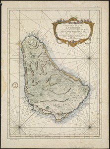
Carte de l'Isle de La Barbade : avec une description geographique de cette isle
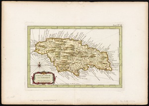
8.
Carte de l'Isle de la Jamaique
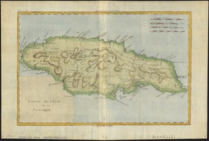
9.
Carte de l'isle de la Jamaïque
10.
A chart of Montego Bay on the north west shore of the island of Jamaica : Port Antonio on the north east shore of the island of...
11.
Jamaica, from the latest surveys
12.
Carta esferica que comprende una parta de las Islas Antillas, las de Puerto Rico, Santo Domingo y Jamayca y Cuba : con los...
13.
Carte des isles Antilles et du Golfe du Mexique : avec la majeure partie de la nouvelle Espagne
14.
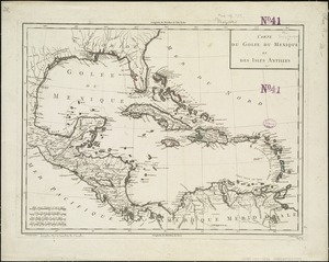
Carte du Golfe du Mexique et des Isles Antilles
15.
Carte du Golphe du Mexique et des isles Antilles : reduite de la grande carte angloise de Popple
16.
Carte du Mexique et des Etats Unis d'Amérique, partie meridionale
17.
Chart of South America, comprehending the West Indies, with the adjacent islands, in the Southern Ocean, and South Sea
18.
Les grandes et petites isles Antilles, et les isles Lucayes avec une partie de la mer du Nord
19.
A map of the English, French, Spanish, Dutch, & Danish Islands, in the West Indies, taken from an improved map of the...
20.
A new & accurate map of the West Indies and the adjacent parts of North & South America
‹ Prev
Next ›
1
2
3
4
5
…
31
32