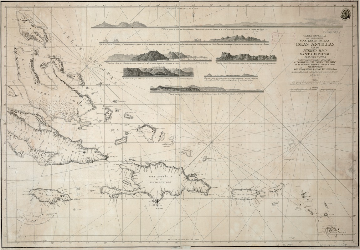
Carta esferica que comprende una parta de las Islas Antillas, las de Puerto Rico, Santo Domingo y Jamayca y Cuba : con los bancos y canales adyacentes
This map is also available in American Revolutionary Geographies Online (ARGO), a collections portal especially built for material relating to the American Revolutionary War Era. Visit ARGO to learn more about this item and explore the historical geography of North America in the late eighteenth century.
Item Information
- Title:
- Carta esferica que comprende una parta de las Islas Antillas, las de Puerto Rico, Santo Domingo y Jamayca y Cuba : con los bancos y canales adyacentes
- Description:
-
Cuba, Hispaniola, and Puerto Rico, the focus of Spanish colonial interest in the West Indies, are depicted on this 1799 nautical chart of the Greater Antilles, published by the Spanish Hydrographic Office. It is based on information provided by Spanish admiral Juan de Langara, who participated in several battles for possession of the islands. At the top, there are seven headland views, provided to assist sailors in easily recognizing island and harbor coast lines. The legend also notes how latitude and longitude were computed for various sites. During this period, computation of longitude had not been perfected, and the east-west position of a ship was calculated using a variety of methods including astronomical observations (comparison of the time on ship of a predictable astronomical event with the time it would have been visible at a prime meridian) and maritime clocks (the use of two clocks, one set to local time each day at noon, and one set to the time at a prime meridian). In this case the prime meridian, the point from which longitude was measured, was Cadiz.
- Creator:
- Bauzá, Felipe, ca. 1750-1833
- Name on Item:
-
Felipe Bauzá, lo delino ; Fernando Selma, lo grabó.
- Date:
-
1799
- Format:
-
Maps/Atlases
- Location:
-
Boston Public Library
Norman B. Leventhal Map & Education Center - Collection (local):
-
Norman B. Leventhal Map & Education Center Collection
- Subjects:
-
Nautical charts--West Indies--Early works to 1800
West Indies--Maps--Early works to 1800
- Places:
-
West Indies
- Extent:
- 1 map ; 86 x 60 cm.
- Terms of Use:
-
No known copyright restrictions.
No known restrictions on use.
- Publisher:
-
[Madrid] :
Depósito Hidrografico de Marina
- Scale:
-
Scale not given.
- Language:
-
Spanish
- Notes:
-
Relief shown by hachures.
Includes 6 elevations in upper section.
Depths shown by soundings.
Exhibited in “Faces and Places,” at the Boston Public Library, Boston, MA, October 2003 - September 2004. MB (BRL)
- Identifier:
-
05_04_000129
- Call #:
-
G4900 1799 .B3
- Barcode:
-
39999052509948
![A new and improved chart of the West India or Carribbee [sic] Islands](https://bpldcassets.blob.core.windows.net/derivatives/images/commonwealth:kk91fq95z/image_thumbnail_300.jpg)


