Toggle navigation
LMEC Home
Exhibitions
Georeferencing
Tools for Teachers
Collections
My Favorites
Sign Up / Log In
Search
Search the map portal
Map Collection
Map Collection
Map Sets
Search
Search
Search for
Search In
All Fields
Creator
Title
Subject
Place
Search All Digital Collections
Advanced Search
13680 Results
Filter your Search
Place
North and Central America
10,344
United States
8,475
Massachusetts
2,789
Suffolk (county)
1,677
Boston
1,633
Europe
1,415
Canada
950
New York
649
more
Place
»
Topic
Boston (Mass.)--Maps
747
City planning--Massachusetts--Boston--Maps
418
United States--History--Revolution, 1775-1783--Maps
329
United States--Maps
322
Real property--Massachusetts--Boston--Maps
254
Urban renewal--Massachusetts--Boston--Maps
254
Massachusetts--Maps
231
Insurance surveys
197
more
Topic
»
Date
Date range begin
–
Date range end
Current results range from
1482
to
2023
View distribution
Creator
United States. Hydrographic Office
597
Boston Redevelopment Authority
404
Des Barres, Joseph F. W. (Joseph Frederick Wallet), 1722-1824
247
Royal United Services Institute for Defence and Security Studies
160
Jefferys, Thomas, -1771
154
George, III, King of Great Britain, 1738-1820
152
George, IV, King of Great Britain, 1762-1830
151
O.H. Bailey & Co
148
more
Creator
»
Format
Maps/Atlases
13,499
Manuscripts
985
Prints
102
Books
49
Drawings/Illustrations
44
Photographs
15
Objects/Artifacts
13
Documents
7
more
Format
»
Georeferenced
Yes
979
No
12,701
Collection
Norman B. Leventhal Map & Education Center Collection
9,096
American Revolutionary War-Era Maps
3,305
Boston and New England Maps
2,915
Urban Maps
2,471
Maritime Charts and Atlases
1,169
William L. Clements Library Collection
910
Library of Congress Collection
618
Boston Redevelopment Authority Collection
475
more
Collection
»
Available to use
No known restrictions
10,246
Creative Commons license
1,678
Search Constraints
Sort by relevance
relevance
title
date (asc)
date (desc)
Number of results to display per page
20 per page
10
per page
20
per page
50
per page
100
per page
View results as:
grid view
map view
Search Results
2161.
Chart of Buffalo Harbor and head of Niagara River with the outlet of Lake Erie
2162.
A chart of Canada River : from ye island of Anticosty as far up as Quebeck, ye islands, locks, shoals, & soundings as they...
2163.
A chart of Cape Breton and St. John's Islands &c. in the gulph of St. Lawrence
2164.
Chart of Cape Cod Harbor and the adjacent coast of Provincetown and Truro
2165.
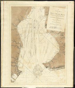
A chart of Delawar Bay, with soundings and nautical observations
2166.
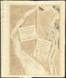
A chart of Delawar River from Bombay Hook to Ridley Creek, with soundings &c taken by Lt. Knight of the Navy
2167.
A chart of Delaware Bay and River, containing a full and exact description of the shores, creeks, harbours, soundings, shoals,...
2168.
Chart of Detroit River
2169.
Chart of Georges Shoal & Bank
2170.
Chart of Georges Shoal & Bank
2171.
Chart of Isle Royale including north west coast of Lake Superior
2172.
Chart of Jamaica Pond and plan of surroundings
2173.
Chart of Lake Saint Clair
2174.
Chart of Long Pond ; Chart of Spot Pond
2175.
[Chart of Maldonado and the Island of Gorriti]
2176.
A chart of Massachusetts Bay
2177.
Chart of Milford Haven, Wales
2178.
A chart of Montego Bay on the north west shore of the island of Jamaica : Port Antonio on the north east shore of the island of...
2179.
[Chart of Nantucket Island and the eastern half of Martha's Vineyard]
2180.
A chart of Nantucket Shoals
‹ Prev
Next ›
1
2
…
105
106
107
108
109
110
111
112
113
…
683
684


![[Chart of Maldonado and the Island of Gorriti]](https://bpldcassets.blob.core.windows.net/derivatives/images/commonwealth:w9505s53p/image_thumbnail_300.jpg)


![[Chart of Nantucket Island and the eastern half of Martha's Vineyard]](https://bpldcassets.blob.core.windows.net/derivatives/images/commonwealth:7h149z54k/image_thumbnail_300.jpg)
