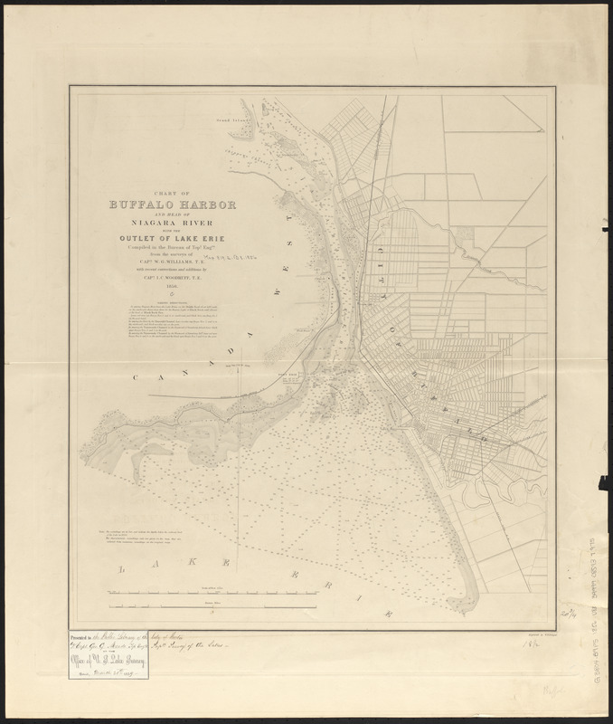
Chart of Buffalo Harbor and head of Niagara River with the outlet of Lake Erie
Item Information
- Title:
- Chart of Buffalo Harbor and head of Niagara River with the outlet of Lake Erie
- Issuing body:
- U.S. Lake Survey
- Surveyor:
- Williams, W. G. (William G.), -1846
- Surveyor:
- Woodruff, I. C.
- Engraver:
- Dougal, William H., 1822-1895
- Name on Item:
-
compiled in the Bureau of Topl. Engrs. from the surveys of Capt. W.G. Williams, T.E. with recent corrections and additions by Capt. I.C. Woodruff, T.E. ; engraved by W.H. Dougal
- Date:
-
1856
- Format:
-
Maps/Atlases
- Location:
-
Boston Public Library
Norman B. Leventhal Map & Education Center - Collection (local):
-
Norman B. Leventhal Map & Education Center Collection
- Subjects:
-
Harbors--New York (State)--Buffalo--Maps
Nautical charts--New York (State)--Buffalo
Niagara River (N.Y. and Ont.)--Maps
Buffalo (N.Y.)--Maps
- Places:
-
Niagara River
New YorkErie (county)Buffalo
- Extent:
- 1 map ; 53 x 48 cm
- Terms of Use:
-
No known copyright restrictions.
No known restrictions on use.
- Publisher:
-
[Washington, D.C.?] :
[U.S. Lake Survey]
- Scale:
-
Scale 1:30,000
- Language:
-
English
- Notes:
-
Depths shown by gradient tints and soundings.
Label pasted in lower left corner: Presented to the Public Library of the City of Boston by Capt. Geo. G. Meade Top. Engrs. Supdt. Survey of the Lakes.
- Identifier:
-
06_01_015591
- Call #:
-
G3804.B9P5 1856 .U83
- Barcode:
-
39999085937975