Toggle navigation
LMEC Home
Exhibitions
Georeferencing
Tools for Teachers
Collections
My Favorites
Sign Up / Log In
Search
Search the map portal
Map Collection
Map Collection
Map Sets
Search
Search
Search for
Search In
All Fields
Creator
Title
Subject
Place
Search All Digital Collections
Advanced Search
2888 Results
My Search
Start Over
atlas
Remove constraint atlas
Filter your Search
Place
North and Central America
1,673
United States
1,009
Europe
470
Massachusetts
359
Canada
271
South America
193
Asia
192
Suffolk (county)
165
more
Place
»
Topic
Landowners--Massachusetts--Boston--Maps
115
Real property--Massachusetts--Boston--Maps
106
United States--Maps
87
Boston (Mass.)--Maps
64
United States--History--French and Indian War, 1754-1763--Maps
63
Saint Lawrence River--Maps
41
Nautical charts--Early works to 1800
39
North America--Maps--Early works to 1800
36
more
Topic
»
Date
Date range begin
–
Date range end
Current results range from
1482
to
2023
View distribution
Creator
United States. Hydrographic Office
584
Des Barres, Joseph F. W. (Joseph Frederick Wallet), 1722-1824
118
Ptolemy, 2nd cent
100
Bromley, George Washington
99
Bromley, Walter Scott
97
G.W. Bromley & Co.
75
Carey, Mathew, 1760-1839
74
Paullin, Charles Oscar, 1868 or 1869-1944
70
more
Creator
»
Format
Maps/Atlases
2,872
Manuscripts
58
Books
37
Prints
8
Documents
5
Drawings/Illustrations
1
Georeferenced
Yes
142
No
2,746
Collection
Norman B. Leventhal Map & Education Center Collection
2,431
Maritime Charts and Atlases
1,169
American Revolutionary War-Era Maps
504
Boston and New England Maps
386
Urban Maps
271
Massachusetts Real Estate Atlases
144
William L. Clements Library Collection
92
Mapping Boston Collection
61
more
Collection
»
Available to use
No known restrictions
2,337
Creative Commons license
158
Search Constraints
Sort by relevance
relevance
title
date (asc)
date (desc)
Number of results to display per page
20 per page
10
per page
20
per page
50
per page
100
per page
View results as:
grid view
map view
Search Results
1561.
Safatu or Sanaapu, island of Upolu ; Harbour of Falifa, island of Upolu
1562.
Saginaw Bay and part of Lake Huron
1563.
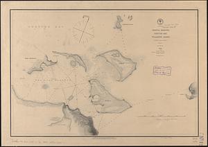
Samoan Group--Tutuila Id.
1564.
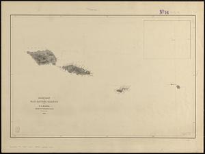
Samoan or Navigator Islands
1565.
Samoan or Navigator Islands
1566.
S.e. coast of Nova Scotia : from the most recent British surveys
1567.
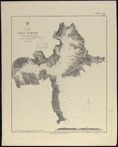
Sea of Japan, Oki Island, Saigo Harbor : from a Japanese government survey in 1879
1568.
Sea of Japan, west coast of Yezo, dangers off the south point of Okosiri Island : from an examination by the officers of the...
1569.
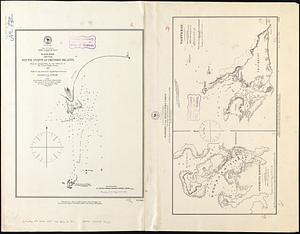
Seagull Harbour, Gretton Bay, Wollaston Island, Tierra del Fuego
1570.
Seagull Harbour, Gretton Bay, Wollaston Island, Tierra del Fuego
1571.
Al sermo. Ferdinando. II. Grandvca di Toscana svo signore Don Roberto Dudleo, Duca di Northumbria
1572.
Shah Bay, Loo Choo I.
1573.
Simoda Harbor, I. of Nippon
1574.
Society Islands, the n.w. coast of Tahiti from Papeete to Point Venus, embracing the harbors of Papeete, Tau-noa and Papawa and...
1575.
South America, anchorages in Magellan Strait : from the most recent British surveys
1576.
South America, Chile, Port of Valdivia and approaches : from a Chilean government survey in 1868-70 corrected to 1882
1577.
South America, Chili, Valparaiso Bay : from a Chilian survey in 1877
1578.
South America, coast of Peru, Ancon Bay : from an Italian survey in 1883
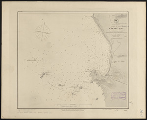
1579.
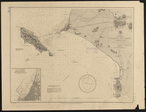
South America, coast of Peru, Callao Bay and vicinity : from a British survey in 1840, and a French survey in 1876
1580.
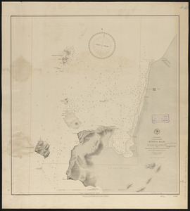
South America, coast of Peru, Pisco Bay : from the latest French and English charts, 1885
‹ Prev
Next ›
1
2
…
75
76
77
78
79
80
81
82
83
…
144
145