Toggle navigation
LMEC Home
Exhibitions
Georeferencing
Tools for Teachers
Collections
My Favorites
Sign Up / Log In
Search
Search the map portal
Map Collection
Map Collection
Map Sets
Search
Search
Search for
Search In
All Fields
Creator
Title
Subject
Place
Search All Digital Collections
Advanced Search
2888 Results
My Search
Start Over
atlas
Remove constraint atlas
Filter your Search
Place
North and Central America
1,673
United States
1,009
Europe
470
Massachusetts
359
Canada
271
South America
193
Asia
192
Suffolk (county)
165
more
Place
»
Topic
Landowners--Massachusetts--Boston--Maps
115
Real property--Massachusetts--Boston--Maps
106
United States--Maps
87
Boston (Mass.)--Maps
64
United States--History--French and Indian War, 1754-1763--Maps
63
Saint Lawrence River--Maps
41
Nautical charts--Early works to 1800
39
North America--Maps--Early works to 1800
36
more
Topic
»
Date
Date range begin
–
Date range end
Current results range from
1482
to
2023
View distribution
Creator
United States. Hydrographic Office
584
Des Barres, Joseph F. W. (Joseph Frederick Wallet), 1722-1824
118
Ptolemy, 2nd cent
100
Bromley, George Washington
99
Bromley, Walter Scott
97
G.W. Bromley & Co.
75
Carey, Mathew, 1760-1839
74
Paullin, Charles Oscar, 1868 or 1869-1944
70
more
Creator
»
Format
Maps/Atlases
2,872
Manuscripts
58
Books
37
Prints
8
Documents
5
Drawings/Illustrations
1
Georeferenced
Yes
142
No
2,746
Collection
Norman B. Leventhal Map & Education Center Collection
2,431
Maritime Charts and Atlases
1,169
American Revolutionary War-Era Maps
504
Boston and New England Maps
386
Urban Maps
271
Massachusetts Real Estate Atlases
144
William L. Clements Library Collection
92
Mapping Boston Collection
61
more
Collection
»
Available to use
No known restrictions
2,337
Creative Commons license
158
Search Constraints
Sort by relevance
relevance
title
date (asc)
date (desc)
Number of results to display per page
20 per page
10
per page
20
per page
50
per page
100
per page
View results as:
grid view
map view
Search Results
1521.
North Pacific Ocean, Loo Choo Archipelago-- Ou-sima, Hancock Bay : from British surveys in 1872 & 1882
1522.
North Pacific Ocean, Marshall Islands, Likieb Group : from a sketch made by Captain J.V. Melander in 1885
1523.
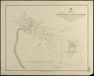
North Pacific Ocean, Midway Islands, Seward Roads and Welles Harbor
1524.
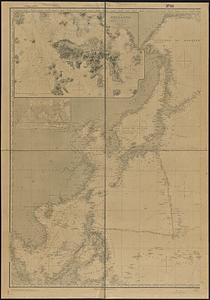
North Pacific Ocean, sheet IV
1525.
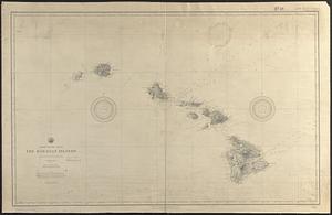
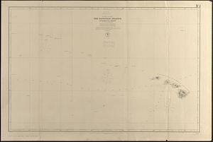
North Pacific Ocean, the Hawaiian Islands : compiled from the latest information
1526.
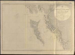
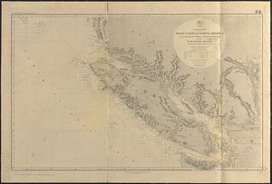
North Pacific Ocean, west coast of North America between latitudes 51° 30' and 55° 30' N. embracing the Queen Charlotte...
1527.
North Pacific Ocean, west coast of North America from the Juan de Fuca Strait to Queen Charlotte Is. including Vancouver Island...
1528.
North Pacific, the Sandwich Islands, with islands and reefs to the westward
1529.
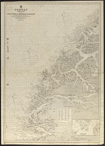
Norway, west coast : from Norwegian surveys, with corrections to 1886
1530.
Nova Scotia, Canso Harbor : from a British survey in 1850-55
1531.
N.w. coast of Peru, Ferrol Bay & Port Chimbote
1532.
Orange Harbour, Tierra del Fuego
1533.
Pacific Ocean, Behrings Sea, Plover Bay : from a survey by Lieut. Maximov Imp! Russian Navy, 1876
1534.
Pacific Ocean, Friendly Islands, Tongatábu : from a British survey in 1852 ; republication of British Admty. chart no. 2363
1535.
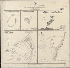
Pacific Ocean, islands of the Mariane and Caroline Groups : from a reconnaissance by the officers of the Imp. German Ship...
1536.
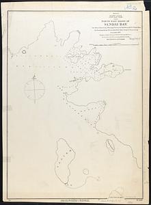
Pacific Ocean, Japan, east coast, north east shore of Sendai Bay
1537.
Pacific Ocean, New Zealand : from surveys in H.M. ships Acheron, & Pandora
1538.
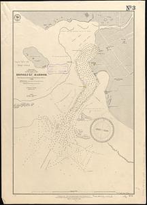
Pacific Ocean, Sandwich Islands, south coast of Oahu, Honolulu Harbor : from surveys by British and United States officers to 1888
1539.
Pacific Ocean, Solomon Is., part of the west coast of Bougainville Island
1540.
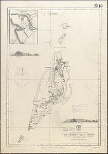
Pacific Ocean, western Caroline Islands, the Pelew (Palau) Group : from a reconnaissance by the officers of the Imp. German...
‹ Prev
Next ›
1
2
…
73
74
75
76
77
78
79
80
81
…
144
145