Pacific Ocean, islands of the Mariane and Caroline Groups : from a reconnaissance by the officers of the Imp. German Ship Hertha, Capt. E. Knorr comdg., 1876
Item Information
- Title:
- Pacific Ocean, islands of the Mariane and Caroline Groups : from a reconnaissance by the officers of the Imp. German Ship Hertha, Capt. E. Knorr comdg., 1876
- Title (alt.):
-
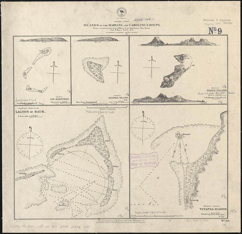
Islands of the Mariane and Caroline Groups
- Issuing body:
- United States. Hydrographic Office
- Date:
-
1877
- Format:
-
Maps/Atlases
- Genre:
-
Nautical charts
- Location:
-
Boston Public Library
Norman B. Leventhal Map & Education Center - Collection (local):
-
Norman B. Leventhal Map & Education Center Collection
- Subjects:
-
Pulap Atoll (Micronesia)--Maps
Satawal Island (Micronesia)--Maps
Pagan Island (Northern Mariana Islands)--Maps
Woleai Atoll (Micronesia)--Maps
Tanapag Harbor (Northern Mariana Islands)--Maps
Nautical charts--Micronesia (Federated States)--Pulap Atoll
Nautical charts--Micronesia (Federated States)--Satawal Island
Nautical charts--Northern Mariana Islands--Pagan Island
Nautical charts--Micronesia (Federated States)--Woleai Atoll
Nautical charts--Northern Mariana Islands--Tanapag Harbor
- Places:
-
Federated States of MicronesiaChuukPulap (atoll)
Northern Mariana Islands (territory)Pagan Island (island)
Federated States of MicronesiaYapWoleai (atoll)
Satawal Island
Puetton Tanapag
- Extent:
- 5 maps on 1 sheet ; 35 x 41 cm
- Terms of Use:
-
No known copyright restrictions.
No known restrictions on use.
- Publisher:
-
Washington, D.C. :
Hydrographic Office
- Scale:
-
Scales differ
- Language:
-
English
- Table of Contents:
-
Los Martires
Satawal Island
Pagan Island
Lagoon of Raur
Tanapag Harbor
- Notes:
-
Relief shown by hachures and spot heights. Depths shown by soundings and pictorially.
Includes 3 coastal views.
- Identifier:
-
06_01_017536
- Call #:
-
G9096.P5 svar .U55 no. 802
- Barcode:
-
39999085960480


