Norway, west coast : from Norwegian surveys, with corrections to 1886
Item Information
- Title:
- Norway, west coast : from Norwegian surveys, with corrections to 1886
- Title (alt.):
-
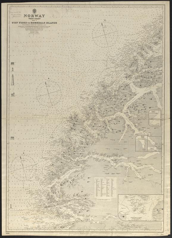
Stav Fiord to Romsdals Islands
- Issuing body:
- Great Britain. Hydrographic Office
- Engraver:
- Weller, Edward, -1884
- Publisher:
- Great Britain. Admiralty
- Name on Item:
-
engraved by Edwd. Weller
- Date:
-
[1903]
- Format:
-
Maps/Atlases
- Genre:
-
Nautical charts
- Location:
-
Boston Public Library
Norman B. Leventhal Map & Education Center - Collection (local):
-
Norman B. Leventhal Map & Education Center Collection
- Subjects:
-
Sogn og Fjordane fylke (Norway)--Maps
Møre og Romsdal fylke (Norway)--Maps
Nautical charts--Norway--Sogn og Fjordane fylke
Nautical charts--Norway--Møre og Romsdal fylke
- Places:
-
NorwaySogn og Fjordane (former administrative division)
NorwayMøre og Romsdal (county)
- Extent:
- 1 map ; 91 x 63 cm
- Terms of Use:
-
No known copyright restrictions.
No known restrictions on use.
- Publisher:
-
London :
Published at the Admiralty
- Scale:
-
Scale approximately 1:190,000
- Language:
-
English
- Notes:
-
Relief shown by hachures and spot heights. Depths shown by soundings and isolines.
Includes note, illustrations of lighthouses and 4 insets.
Also indicates visibility of lighthouses.
Insets: Hjörung Fiord, Saebo -- Nord Fiord, Indvik Fiord, Olden -- Gerianger Fiord, Merok -- Approaches to Frekö and adjacent anchorages.
Originally published 1881, with large corrections to June 1896 and small correction to X.03.
"449."--Lower left corner.
"2305."--Lower right corner.
- Notes (date):
-
This date is inferred.
- Identifier:
-
06_01_017612
- Call #:
-
G9096.P5 svar .G74 no. 2305
- Barcode:
-
39999085961751


