Toggle navigation
LMEC Home
Exhibitions
Georeferencing
Tools for Teachers
Collections
My Favorites
Sign Up / Log In
Search
Search the map portal
Map Collection
Map Collection
Map Sets
Search
Search
Search for
Search In
All Fields
Creator
Title
Subject
Place
Search All Digital Collections
Advanced Search
2888 Results
My Search
Start Over
atlas
Remove constraint atlas
Filter your Search
Place
North and Central America
1,673
United States
1,009
Europe
470
Massachusetts
359
Canada
271
South America
193
Asia
192
Suffolk (county)
165
more
Place
»
Topic
Landowners--Massachusetts--Boston--Maps
115
Real property--Massachusetts--Boston--Maps
106
United States--Maps
87
Boston (Mass.)--Maps
64
United States--History--French and Indian War, 1754-1763--Maps
63
Saint Lawrence River--Maps
41
Nautical charts--Early works to 1800
39
North America--Maps--Early works to 1800
36
more
Topic
»
Date
Date range begin
–
Date range end
Current results range from
1482
to
2023
View distribution
Creator
United States. Hydrographic Office
584
Des Barres, Joseph F. W. (Joseph Frederick Wallet), 1722-1824
118
Ptolemy, 2nd cent
100
Bromley, George Washington
99
Bromley, Walter Scott
97
G.W. Bromley & Co.
75
Carey, Mathew, 1760-1839
74
Paullin, Charles Oscar, 1868 or 1869-1944
70
more
Creator
»
Format
Maps/Atlases
2,872
Manuscripts
58
Books
37
Prints
8
Documents
5
Drawings/Illustrations
1
Georeferenced
Yes
142
No
2,746
Collection
Norman B. Leventhal Map & Education Center Collection
2,431
Maritime Charts and Atlases
1,169
American Revolutionary War-Era Maps
504
Boston and New England Maps
386
Urban Maps
271
Massachusetts Real Estate Atlases
144
William L. Clements Library Collection
92
Mapping Boston Collection
61
more
Collection
»
Available to use
No known restrictions
2,337
Creative Commons license
158
Search Constraints
Sort by relevance
relevance
title
date (asc)
date (desc)
Number of results to display per page
20 per page
10
per page
20
per page
50
per page
100
per page
View results as:
grid view
map view
Search Results
1421.
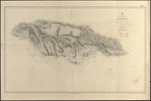
North America, east coast, West Indies, Jamaica : from British surveys from 1873 to 1881
1422.
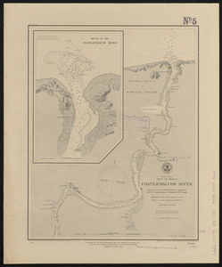
North America, Gulf of Mexico, Coatzacoalcos River : from a survey by the U.S. Tehuantepec Expedition, in 1870-71, Captain...
1423.
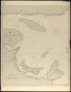
North America, Gulf of Saint Lawrence : compiled from the latest information
1424.
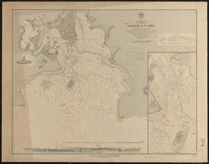
North America, New Brunswick, Harbor of St. John : from the latest British surveys
1425.
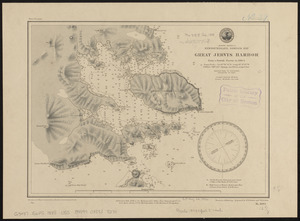
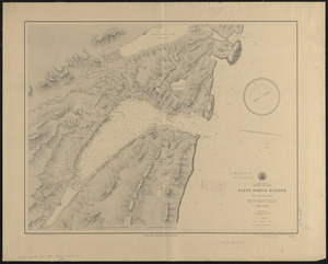
North America, Newfoundland, Despair Bay, Great Jervis Harbor : from a British survey in 1884-5
1426.
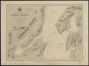
North America, Newfoundland, Fortune Bay, Harbor Breton from a British survey in 1882
1427.
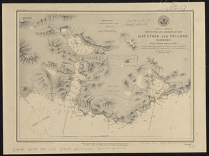
North America, Newfoundland, Hermitage Bay, Gaultois and Picarre Harbors : from a British survey in 1883
1428.
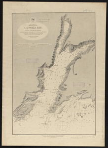
North America, Newfoundland, La Poile Bay : from the latest British surveys
1429.
North America, Newfoundland, Saint John's Harbor : from a British survey in 1885
1430.
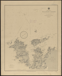
North America, Newfoundland, Twillingate Harbors (Toulinguet Harbors) : from a British survey in 1877
1431.
North America, north east coast of Newfoundland, Cape Onion to Hare Bay
1432.
North America, Nova Scotia, Halifax Harbor : from the latest British surveys
1433.
North America, Pacific coast of Mexico and Central America, San Blas to Panama : compiled from the latest British and United...
1434.
North America, Pacific coast of the United States and Mexico, San Francisco to San Blas : compiled from the latest United...
1435.
North America, River St. Lawrence above Quebec
1436.
North America, River St. Lawrence above Quebec
1437.
North America, River St. Lawrence, Montreal Harbour
1438.
North America, south coast of Newfoundland : Devil Bay to Knife Bay : from a British survey in 1872 & 1873 ; republication of...
1439.
North America, south coast of Newfoundland from the Burgeo Islands to Cape St. Mary : compiled from the latest information
1440.
North America, south coast of Newfoundland, Lamalin anchorages : from a British survey in 1884
‹ Prev
Next ›
1
2
…
68
69
70
71
72
73
74
75
76
…
144
145