Toggle navigation
LMEC Home
Exhibitions
Georeferencing
Tools for Teachers
Collections
My Favorites
Sign Up / Log In
Search
Search the map portal
Map Collection
Map Collection
Map Sets
Search
Search
Search for
Search In
All Fields
Creator
Title
Subject
Place
Search All Digital Collections
Advanced Search
2843 Results
My Search
Start Over
atlas
Remove constraint atlas
Filter your Search
Place
North and Central America
1,647
United States
987
Europe
464
Massachusetts
348
Canada
271
Asia
190
South America
189
Suffolk (county)
163
more
Place
»
Topic
Landowners--Massachusetts--Boston--Maps
115
Real property--Massachusetts--Boston--Maps
106
United States--Maps
87
Boston (Mass.)--Maps
63
United States--History--French and Indian War, 1754-1763--Maps
63
Saint Lawrence River--Maps
41
Nautical charts--Early works to 1800
39
North America--Maps--Early works to 1800
36
more
Topic
»
Date
Date range begin
–
Date range end
Current results range from
1482
to
2023
View distribution
Creator
United States. Hydrographic Office
582
Des Barres, Joseph F. W. (Joseph Frederick Wallet), 1722-1824
118
Ptolemy, 2nd cent
100
Bromley, George Washington
99
Bromley, Walter Scott
97
G.W. Bromley & Co.
75
Carey, Mathew, 1760-1839
74
Paullin, Charles Oscar, 1868 or 1869-1944
70
more
Creator
»
Format
Maps/Atlases
2,827
Manuscripts
58
Books
37
Prints
8
Documents
5
Drawings/Illustrations
1
Georeferenced
Yes
142
No
2,701
Collection
Norman B. Leventhal Map & Education Center Collection
2,386
Maritime Charts and Atlases
1,150
American Revolutionary War-Era Maps
504
Boston and New England Maps
374
Urban Maps
250
Massachusetts Real Estate Atlases
144
William L. Clements Library Collection
92
Mapping Boston Collection
61
more
Collection
»
Available to use
No known restrictions
2,292
Creative Commons license
158
Search Constraints
Sort by relevance
relevance
title
date (asc)
date (desc)
Number of results to display per page
20 per page
10
per page
20
per page
50
per page
100
per page
View results as:
grid view
map view
Search Results
2801.
The American pilot : containing the navigation of the sea coat of North America . . .
2802.
A new map of the world according to Wrights alias Mercators projection &c : drawn from the newest and the most exact...
2803.
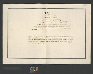
Plan of that part of Canada and the River St. Lawrence which lies between Dechambeaux and Pointe du Lac on the north shore...
2804.
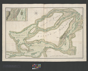
The St. Lawrence River between Coteau des Cedres and Varennes
2805.
Amerique meridionale divisée en ses principales parties ou sont distingués les vns des autres les estats suivant qu'ils...
2806.
The St. Lawrence River between Trois Rivières and Grondines Parish
2807.
A PLAN OF HALIFAX HARBOUR IN NOVA SCOTIA 1760
2808.
Carte chorographique des Pays-Bas Autrichiens
2809.
Insurance map of Boston : volume 2
2810.
Insurance map of Boston : volume 2
2811.
Insurance map of Boston : volume 1
2812.
Insurance map of Boston vol. 3 (South & East Boston)
2813.
Insurance map of Charlestown : portions of Roxbury (now annexed to Boston) and Cambridge : 1868 : corrected Nov. 1871
2814.
Insurance map of Charlestown : portions of Roxbury (now annexed to Boston) and Cambridge
2815.
Insurance maps of Boston volume one
2816.
Insurance maps of Boston volume two
2817.
Insurance maps of Gloucester, Massachusetts
2818.
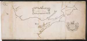
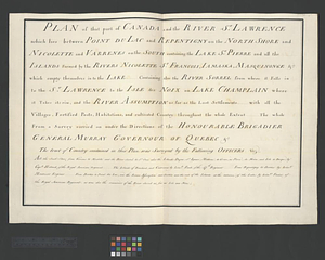
Plan of that part of Canada and the River St. Lawrence which lies between Pointe du Lac and Repentigny on the North Shore and...
2819.
City of Melrose assessors plans
2820.
Gilbertville, Worcester County, Massachusetts
‹ Prev
Next ›
1
2
…
137
138
139
140
141
142
143