Amerique meridionale divisée en ses principales parties ou sont distingués les vns des autres les estats suivant qu'ils appartiennent présentement aux François, Castillans, Portugais, Hollandois, &c
Item Information
- Title:
- Amerique meridionale divisée en ses principales parties ou sont distingués les vns des autres les estats suivant qu'ils appartiennent présentement aux François, Castillans, Portugais, Hollandois, &c
- Title (alt.):
-
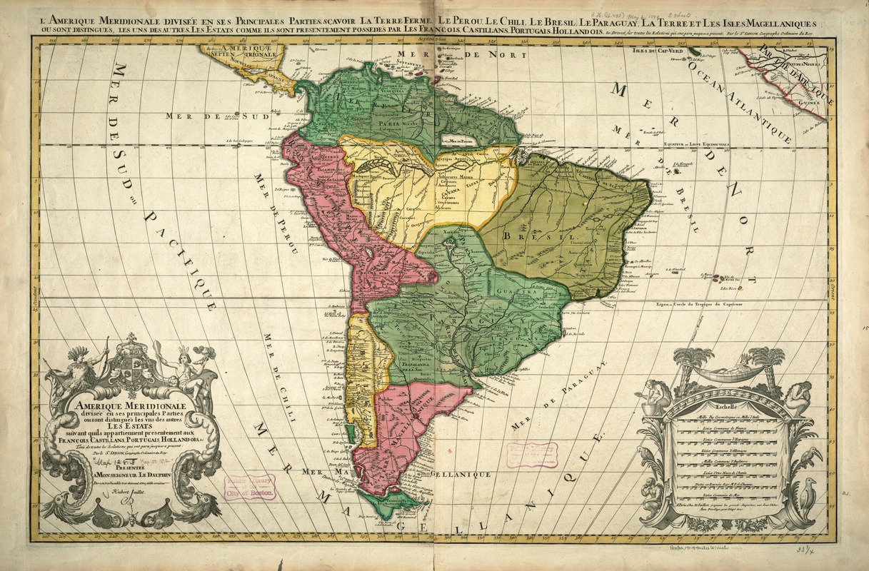
L'Amerique meridionale divisée en ses principales parties, sçavoir la Terre Ferme, le Perou, le Chili, le Bresil, le Paraguay, le Terre et les isles Magellaniques, ou sont distingués, les uns des autres, les estats comme ils sont presentement possedés par les Francois, Castillans, Portugais, Hollandois, & dressée sur toutes les relations qui ont paru jusques a present
- Creator:
- Sanson, Nicolas, 1600-1667
- Name on Item:
-
tirée de toutes les relations qui ont paru jusques a present par le Sr. Sanson, geographe ordinaire du roy.
- Date:
-
1691
- Format:
-
Maps/Atlases
- Location:
-
Boston Public Library
Norman B. Leventhal Map & Education Center - Collection (local):
-
Norman B. Leventhal Map & Education Center Collection
- Subjects:
-
South America--Maps--Early works to 1800
- Places:
-
South America
South America
- Extent:
- 1 map : hand col. ; 63 x 96 cm.
- Terms of Use:
-
No known copyright restrictions.
No known restrictions on use.
- Publisher:
-
Paris :
Chez H. Iaillot, joignant les grands Augustins, aux deux Globes, avec privilege
- Scale:
-
Scale [ca. 1:16,000,000].
- Language:
-
French
- Notes:
-
Relief shown pictorially.
Dedication: "Presentée a Monseigneur le Dauphin par son tres humble, tres obeissant et tres fidéle serviteur Hubert Jaillot."
Colored outlines.
As a reflection of late-17th-century French cartography, this map portrays the political geography of South America, dividing the continent into its various administrative units, emphasizing those under French, Spanish, Portuguese, and Dutch control. The northern part of the continent, an integral part of the Caribbean rimland that is the homeland of many Florida immigrants, is labeled "Terrra Firme." This green-colored area encompasses the present-day countries of Colombia, Venezuela, and the Guianas. Although based on the work of Nicolas Sanson, the founder of the French School of Geography during the middle of the 17th century, this version was reissued by his successor Hubert Jaillot, also a prolific publisher of maps and atlases at the end of the century. Typical of the French cartographic style, the map includes two elaborate cartouches, intertwining images of Native Americans identified with feathered headdresses together with native flora and fauna, especially palm trees and parrots. One cartouche encloses the map's title while the other compares eight different scale bars, recording the diversity of European measurement systems before the adoption of the metric system.
Featured in the Faces & Places Exhibit, Kravis Center, Palm Beach, FL, since 2005. MB (BRL)
- Identifier:
-
05_04_000098
- Call #:
-
G5200 1691 .S35
- Barcode:
-
39999052509229


