Toggle navigation
LMEC Home
Exhibitions
Georeferencing
Tools for Teachers
Collections
My Favorites
Sign Up / Log In
Search
Search the map portal
Map Collection
Map Collection
Map Sets
Search
Search
Search for
Search In
All Fields
Creator
Title
Subject
Place
Search All Digital Collections
Advanced Search
13680 Results
Filter your Search
Place
North and Central America
10,344
United States
8,475
Massachusetts
2,789
Suffolk (county)
1,677
Boston
1,633
Europe
1,415
Canada
950
New York
649
more
Place
»
Topic
Boston (Mass.)--Maps
747
City planning--Massachusetts--Boston--Maps
418
United States--History--Revolution, 1775-1783--Maps
329
United States--Maps
322
Real property--Massachusetts--Boston--Maps
254
Urban renewal--Massachusetts--Boston--Maps
254
Massachusetts--Maps
231
Insurance surveys
197
more
Topic
»
Date
Date range begin
–
Date range end
Current results range from
1482
to
2023
View distribution
Creator
United States. Hydrographic Office
597
Boston Redevelopment Authority
404
Des Barres, Joseph F. W. (Joseph Frederick Wallet), 1722-1824
247
Royal United Services Institute for Defence and Security Studies
160
Jefferys, Thomas, -1771
154
George, III, King of Great Britain, 1738-1820
152
George, IV, King of Great Britain, 1762-1830
151
O.H. Bailey & Co
148
more
Creator
»
Format
Maps/Atlases
13,499
Manuscripts
985
Prints
102
Books
49
Drawings/Illustrations
44
Photographs
15
Objects/Artifacts
13
Documents
7
more
Format
»
Georeferenced
Yes
979
No
12,701
Collection
Norman B. Leventhal Map & Education Center Collection
9,096
American Revolutionary War-Era Maps
3,305
Boston and New England Maps
2,915
Urban Maps
2,471
Maritime Charts and Atlases
1,169
William L. Clements Library Collection
910
Library of Congress Collection
618
Boston Redevelopment Authority Collection
475
more
Collection
»
Available to use
No known restrictions
10,246
Creative Commons license
1,678
Search Constraints
Sort by relevance
relevance
title
date (asc)
date (desc)
Number of results to display per page
20 per page
10
per page
20
per page
50
per page
100
per page
View results as:
grid view
map view
Search Results
3101.
A draught of Boston Harbor by Capt. Cyprian Southake
3102.
A draught of Delaware Bay
3103.
A draught of Lake George, and part of Hudson's River taken September 1756
3104.
A Draught of Lake George with all the Islands & Soundings
3105.
A draught of Massiac Lake, Maurepas, part of the river Amitt and the river Ibberville : copy from Lieut Ph: Pittman
3106.
A draught of New York from the Hook to New York Town
3107.
Draught of part of the province of South Carolina shewing the march & encampments of the British troops under the command of...
3108.
A draught of Rhode Island, 1777
3109.
A draught of Ship & Catt islands and the opposite coast
3110.
A draught of St. John's harbour : with the soundings
3111.
A draught of the barr off Mobile & Dauphine Island
3112.
A draught of the Bay of Honda
3113.
A draught of the bay of Pansacola
3114.
A draught of the Cherokee Country : on the west side of the Twenty Four Mountains, commonly called Over the Hills
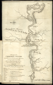
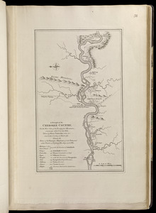
3115.
A draught of the Cherokee Country, on the west side of the Twenty Four Mountains, commonly called Over the Hills
3116.
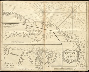
A draught of the coast of Guiana, from the river Oronoque to the river Amazones
3117.
A Draught of the Fortress building at Crown Point 22.d Oct.t 1759
3118.
A draught of the harbor & river of Piscataqua with the Island's of Shoal's
3119.
A draught of the harbor & river of Piscataqua with the Island's of Shoal's
3120.
A draught of the harbour of Hallifax and the adjacent coast in Nova Scotia
‹ Prev
Next ›
1
2
…
152
153
154
155
156
157
158
159
160
…
683
684