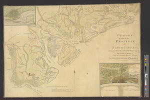
Draught of part of the province of South Carolina shewing the march & encampments of the British troops under the command of Major Genl. Prevost upon an expedition into that province
This map is also available in American Revolutionary Geographies Online (ARGO), a collections portal especially built for material relating to the American Revolutionary War Era. Visit ARGO to learn more about this item and explore the historical geography of North America in the late eighteenth century.
Item Information
- Title:
- Draught of part of the province of South Carolina shewing the march & encampments of the British troops under the command of Major Genl. Prevost upon an expedition into that province
- Title (alt.):
-
Post at Wappoo Cut with the disposition of his majesty's troops on the 24th & 25th of May to bring on a genl. action if the rebels advanced
Plan of the post, occupied by his majesty's troops at Stono attacked by the rebels on the 20th June 1779
- Date:
-
[1779]
- Format:
-
Maps/Atlases
- Genre:
-
Manuscript maps
- Location:
- William L. Clements Library
- Collection (local):
-
William L. Clements Library Collection
- Subjects:
-
Stono Ferry (S.C.), Battle of, 1779--Maps
Wappoo Creek (S.C.)--Maps
United States--History--Revolution, 1775-1783--Maps
Prévost, Augustine, approximately 1725-1786
- Places:
-
South CarolinaCharleston (county)Rantowles
South CarolinaCharleston (county)Wappoo Creek
- Extent:
- 1 ms. map : col. ; 52.2 x 73 cm
- Terms of Use:
-
The University of Michigan Library provides access to these materials for educational and research purposes. These materials may be under copyright. If you decide to use any of these materials, you are responsible for making your own legal assessment and securing any necessary permission. If you have questions about the collection, please contact the William L. Clements Library.
Contact host institution for more information.
- Scale:
-
Scale 1:180,000. Scales of insets vary.
- Language:
-
English
- Catalog Record:
-
Catalog record
- Notes:
-
Finished, colored, topographical map of the coast from Savannah to Charleston showing the movements of Prevost's expedition.
Insets show details of fortifications and troop dispositions at the two posts.
Clinton Maps 307.
- Notes (date):
-
This date is inferred.
- Identifier:
-
625
- Barcode:
-
B1938656


