Toggle navigation
LMEC Home
Exhibitions
Georeferencing
Tools for Teachers
Collections
My Favorites
Sign Up / Log In
Search
Search the map portal
Map Collection
Map Collection
Map Sets
Search
Search
Search for
Search In
All Fields
Creator
Title
Subject
Place
Search All Digital Collections
Advanced Search
10961 Results
My Search
Start Over
All Fields
americas
Remove constraint All Fields: americas
Filter your Search
Place
North and Central America
10,354
United States
8,478
Massachusetts
2,796
Suffolk (county)
1,676
Boston
1,632
Canada
937
New York
650
Middlesex (county)
441
more
Place
»
Topic
Boston (Mass.)--Maps
747
City planning--Massachusetts--Boston--Maps
418
United States--History--Revolution, 1775-1783--Maps
327
United States--Maps
320
Real property--Massachusetts--Boston--Maps
254
Urban renewal--Massachusetts--Boston--Maps
254
Massachusetts--Maps
233
Insurance surveys
194
more
Topic
»
Date
Date range begin
–
Date range end
Current results range from
1507
to
2023
View distribution
Creator
Boston Redevelopment Authority
404
United States. Hydrographic Office
366
Des Barres, Joseph F. W. (Joseph Frederick Wallet), 1722-1824
197
Jefferys, Thomas, -1771
150
George, III, King of Great Britain, 1738-1820
146
O.H. Bailey & Co
146
George, IV, King of Great Britain, 1762-1830
145
Royal United Services Institute for Defence and Security Studies
139
more
Creator
»
Format
Maps/Atlases
10,838
Manuscripts
916
Prints
60
Books
43
Drawings/Illustrations
43
Photographs
15
Objects/Artifacts
7
Posters
3
more
Format
»
Georeferenced
Yes
823
No
10,138
Collection
Norman B. Leventhal Map & Education Center Collection
6,635
American Revolutionary War-Era Maps
3,123
Boston and New England Maps
2,918
Urban Maps
2,294
William L. Clements Library Collection
892
Maritime Charts and Atlases
816
Library of Congress Collection
552
Boston Redevelopment Authority Collection
475
more
Collection
»
Available to use
No known restrictions
7,777
Creative Commons license
1,541
Search Constraints
Sort by relevance
relevance
title
date (asc)
date (desc)
Number of results to display per page
20 per page
10
per page
20
per page
50
per page
100
per page
View results as:
grid view
map view
Search Results
1921.
A plan of the operations of the King's army under the command of General Sr. William Howe, K.B. in New York and east New...
1922.
A plan of the field of battle and disposition of the troops, as they were on the march at the time of the attack on the 9th of...
1923.
A new map of Nova Scotia, and Cape Britain : with the adjacent parts of New England and Canada, composed from a great number of...
1924.
The south east coast of Cape Breton Island
1925.
Geographica restituta per globi trientes
1926.
Septentrionalium terrarum descriptio
1927.
Scandinavia
1928.
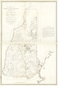
A topographical map of the Province of New Hampshire
1929.
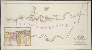
Nieuwe gemeten Kaart van de Colonie de Berbice met der zelver Plantagien en de Namen der Bezitters
1930.
A plan of the city, and fortifications, of Louisburg : from a survey made by Richard Gridley, Lieut. Coll. of the Train of...
1931.
Plan of the town of Boston with the attack on Bunkers-Hill in the peninsula of Charlestown the 17th of June 1775
1932.
Map of the world, on Mercator's projection
1933.
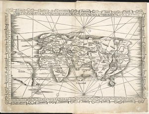
Orbis typus universalis iuxta hydrographorum traditionem exactissime depicta 1522 L.F
1934.
Carte du Canada et des Etats-Unis de l'Amérique Septentrionale
1935.
A correct plan of the environs of Quebec, and of the battle fought on the 13th September, 1759 : together with a particular...
1936.
Boston over Time
1937.
Plan of Fort le Quesne, built by the French at the fort of the Ohio and monongahela in 1754
1938.
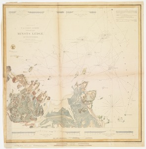
Minots Ledge off Boston Harbor : showing the proposed site of a light house
1939.
[Plan d'Amboy : vues de la rade de Charles-Town et de Fort Sulivan, mai 1780]
1940.
A large and particular plan of Shegnekto Bay, and the circumjacent country, with the forts and settlements of the French 'till...
‹ Prev
Next ›
1
2
…
93
94
95
96
97
98
99
100
101
…
548
549