MBTA flood exposure : 36" SLR 2070s or later
Item Information
- Title:
- MBTA flood exposure : 36" SLR 2070s or later
- Title (alt.):
-
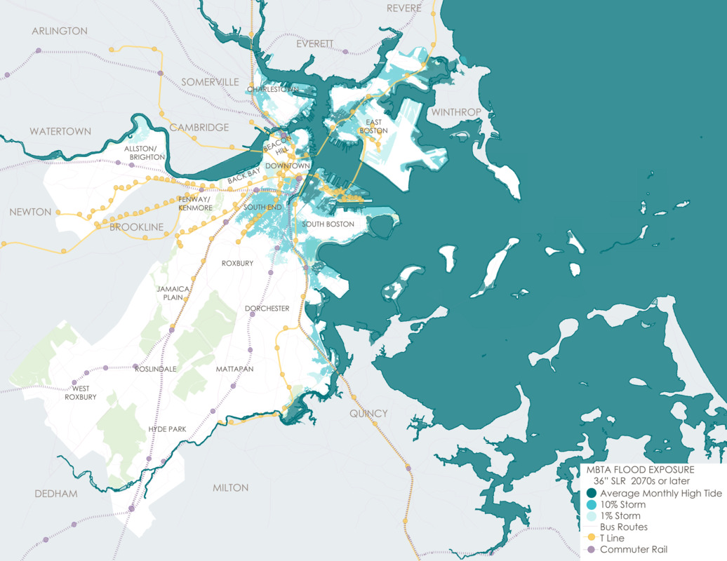
Public transportation exposed to flooding with 36 inch sea level rise
- Description:
-
Thousands of people rely on public transportation each day in Boston. According to Climate Ready Boston, nearly a third of MBTA T stations could be exposed to flooding with increasing sea level rise by the year 2070. This map shows bus, T lines, and commuter rail lines that would be impacted with a thirty-six inch rise in sea level.
- Cartographer:
- Climate Ready Boston
- Date:
-
2016
- Format:
-
Maps/Atlases
- Location:
-
Boston Public Library
Norman B. Leventhal Map & Education Center - Collection (local):
-
Norman B. Leventhal Map & Education Center Collection
- Subjects:
-
Boston (Mass.)--Maps
Sea level--Massachusetts--Boston--Maps
Climatic changes--Massachusetts--Boston--Maps
- Places:
-
MassachusettsSuffolk (county)Boston
- Extent:
- 1 map : color
- Terms of Use:
-
No known copyright restrictions.
No known restrictions on use.
- Publisher:
-
Boston :
Climate Ready Boston
- Language:
-
English
- Notes:
-
The 2016 Climate Ready Boston report was led by the City of Boston in partnership with the Green Ribbon Commission. The project team included the City of Boston, HR&A, Arcadis, Sasaki Associates, and the Boston Research Advisory Group at the University of Massachusetts Boston. Funding was provided by the Barr Foundation, the Massachusetts Coastal Zone Management Program, and the Sherry and Alan Leventhal Foundation.
- Notes (exhibitions):
-
Exhibited: "Regions and Seasons: Mapping Climate through History" organized by the Norman B. Leventhal Map Center at the Boston Public Library, 2017.
- Identifier:
-
CRB_Downtown_map


