Flood progression map : 36" SLR
Item Information
- Title:
- Flood progression map : 36" SLR
- Title (alt.):
-
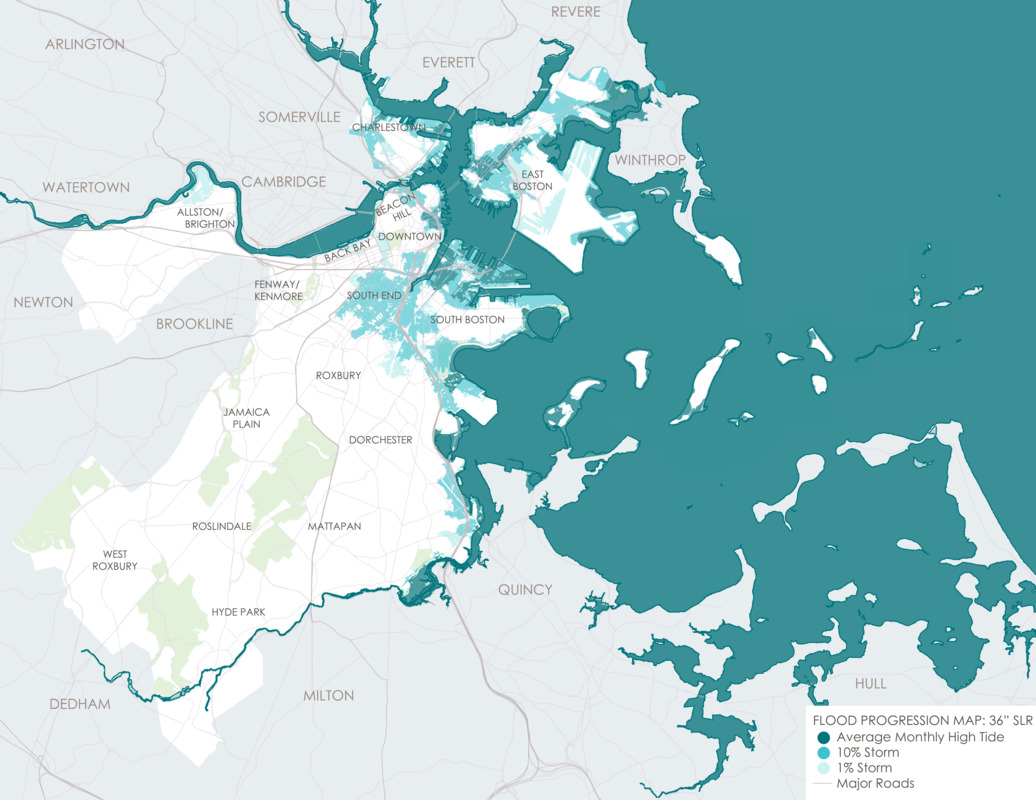
Flood progression – coastal & riverine flooding: 2070s onward
- Description:
-
“Climate risks are not new for Boston, but they will continue to increase as the global climate changes.” Published in Climate Ready Boston’s final report from December 2016, this statement speaks to the past and future efforts by the City to adapt to coastal conditions. Established in 2015, Climate Ready Boston is “an initiative to develop resilient solutions to prepare our City for climate change.” The initiative consists of four components, including updated climate projections, vulnerability assessment, focus areas (geographic locations), and climate resilience initiatives. By the end of the 21st century, sea levels will rise at least thirty-six inches or more, according to this model by Climate Ready Boston. In this long-term outlook, from about 2070 onward, extensive areas of the city will be exposed to flooding, including inland neighborhoods such as the South End. Five percent of Boston’s total land area in the late century will be flooded at high tide at least once a month, even with clear weather. In this map, you can see the Shawmut peninsula is predicted to revert to the shape it was in 1630 in the Downtown region, indicated by white areas.
- Cartographer:
- Climate Ready Boston
- Date:
-
2016
- Format:
-
Maps/Atlases
- Location:
-
Boston Public Library
Norman B. Leventhal Map & Education Center - Collection (local):
-
Norman B. Leventhal Map & Education Center Collection
- Subjects:
-
Boston (Mass.)--Maps
Sea level--Massachusetts--Boston--Maps
Climatic changes--Massachusetts--Boston--Maps
- Places:
-
MassachusettsSuffolk (county)Boston
- Extent:
- 1 map : color
- Terms of Use:
-
No known copyright restrictions.
No known restrictions on use.
- Publisher:
-
Boston :
Climate Ready Boston
- Language:
-
English
- Notes:
-
The 2016 Climate Ready Boston report was led by the City of Boston in partnership with the Green Ribbon Commission. The project team included the City of Boston, HR&A, Arcadis, Sasaki Associates, and the Boston Research Advisory Group at the University of Massachusetts Boston. Funding was provided by the Barr Foundation, the Massachusetts Coastal Zone Management Program, and the Sherry and Alan Leventhal Foundation.
- Notes (exhibitions):
-
Exhibited: "Regions and Seasons: Mapping Climate through History" organized by the Norman B. Leventhal Map Center at the Boston Public Library, 2017.
- Identifier:
-
CRB_base36_final


