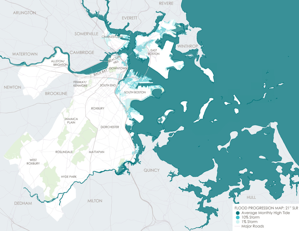
Flood progression map : 21" SLR
Item Information
- Title:
- Flood progression map : 21" SLR
- Title (alt.):
-
Flood progression – coastal & riverine flooding: 2050s-2100
- Description:
-
“Climate risks are not new for Boston, but they will continue to increase as the global climate changes.” Published in Climate Ready Boston’s final report from December 2016, this statement speaks to the past and future efforts by the City to adapt to coastal conditions. Established in 2015, Climate Ready Boston is “an initiative to develop resilient solutions to prepare our City for climate change.” The initiative consists of four components, including updated climate projections, vulnerability assessment, focus areas (geographic locations), and climate resilience initiatives. According to Climate Ready Boston, by the year 2050 sea levels are projected to be as much as eighteen inches higher than they were in the year 2000. This map illustrates the mid-term (2050s-2100s) flood progression if the sea level rises twenty-one inches. In this situation, waterfront neighborhoods situated on the coast or on rivers or riverbanks would see increased flood exposure, and the flood impact in the Dorchester neighborhood would be significant. Climate Ready Boston reports that by the 2050s, all of Morrissey Boulevard, an evacuation route, will be exposed to high probability flood events – events which have a ten percent chance of occurring each year.
- Cartographer:
- Climate Ready Boston
- Date:
-
2016
- Format:
-
Maps/Atlases
- Location:
-
Boston Public Library
Norman B. Leventhal Map & Education Center - Collection (local):
-
Norman B. Leventhal Map & Education Center Collection
- Subjects:
-
Boston (Mass.)--Maps
Sea level--Massachusetts--Boston--Maps
Climatic changes--Massachusetts--Boston--Maps
- Places:
-
MassachusettsSuffolk (county)Boston
- Extent:
- 1 map : color
- Terms of Use:
-
No known copyright restrictions.
No known restrictions on use.
- Publisher:
-
Boston :
Climate Ready Boston
- Language:
-
English
- Notes:
-
The 2016 Climate Ready Boston report was led by the City of Boston in partnership with the Green Ribbon Commission. The project team included the City of Boston, HR&A, Arcadis, Sasaki Associates, and the Boston Research Advisory Group at the University of Massachusetts Boston. Funding was provided by the Barr Foundation, the Massachusetts Coastal Zone Management Program, and the Sherry and Alan Leventhal Foundation.
- Notes (exhibitions):
-
Exhibited: "Regions and Seasons: Mapping Climate through History" organized by the Norman B. Leventhal Map Center at the Boston Public Library, 2017.
- Identifier:
-
CRB_base21_final


